
Quick Summary: What makes Panikhar the ultimate mountain viewpoint in Suru Valley?
Quick Answer: Situated 65 km southeast of Kargil along the surging Suru River at 10,200 ft (3,109 m), Panikhar is a lush, emerald oasis that serves as the premier roadside viewpoint and basecamp staging hub for the monumental Nun-Kun mountain massif. Rising nearly 4,000 vertical meters directly above the green willow meadows, Mount Nun (7,135 m) - the highest peak in UT Ladakh - and its twin sister Mount Kun (7,077 m) form a colossal, sheer wall of hanging glaciers, crystalline icefalls, and rugged granite ridges visible directly from smooth NH301 tarmac.
The Giants of Ladakh: Introducing Panikhar & The Nun-Kun Massif
Answer-First Summary: Gazing upon the towering 7,000-meter snow summits that dominate the skyline of the Greater Himalayas.
Riding southeast from Kargil into the winding gorge of the Suru River along National Highway 301 (NH301), the landscape begins a radical transformation. Leaving behind the dry, brown scree terraces of the Indus drainage, the air turns noticeably sweeter, scented by lush riverside willow groves, yellow rapeseed blooms, and terraced barley fields. After 65 kilometers of sweeping asphalt curves, you roll into the green bowl of Panikhar (10,200 ft / 3,109 m). Cut the throttle, look up toward the southern sky, and your breath catches in your chest.
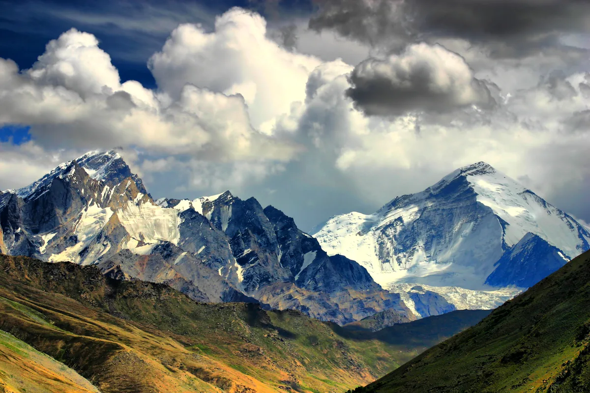
Rising like colossal granite fortresses straight out of the green valley floor are the twin titans of the Zanskar range: Mount Nun (7,135 meters / 23,409 feet) and Mount Kun (7,077 meters / 23,218 feet). Mount Nun is the highest mountain peak in the entire Union Territory of Ladakh, an immense pyramid of blue-white hanging glaciers, seracs, and vertical rock walls that soars more than four thousand vertical meters above the surrounding riverbanks.
While Mount Everest and K2 require weeks of arduous expedition trekking through restricted border zones, the Nun-Kun massif presents one of the most accessible 7,000-meter mountain panoramas on earth. Motorcyclists can park their adventure machines beside the riverbed in Panikhar and gaze directly into the jagged ice falls of the Barmal and Parkachik glaciers without hiking a single step.
For riders mounting dual-sport machines with Ride & Fire Rentals, Panikhar is far more than a scenic photo opportunity. It is the premier strategic staging hub on the expedition route from Kargil into Zanskar - the last outpost with reliable cellular networks, hot meals, comfortable homestays, and smooth tarmac before entering the raw, unpaved wilderness of upper Suru.
Mountaineering Lore: From Workman Expeditions to Modern Alpine Ascents
Answer-First Summary: Tracing the historic climbing expeditions, icefall routes, and the tragic legends of Nun-Kun.
The colossal vertical relief of the Nun-Kun massif has magnetized pioneering mountaineers for over a century.
THE 1898 AND 1906 WORKMAN EXPEDITIONS: The first serious mountaineering exploration of Nun-Kun was undertaken by the eccentric American explorer couple Fanny Bullock Workman and William Hunter Workman in 1906. Fanny Bullock Workman set a world altitude record for female climbers by summiting Pinnacle Peak (6,930 m), an auxiliary crest of the massif, carrying heavy brass surveying equipment and glass photographic plates across uncharted icefields.
THE HISTORIC 1953 FIRST ASCENT: Mount Nun was first successfully summited in 1953 by a French-Swiss expedition led by the legendary alpinist Pierre Vittoz and the British climber Claude Kogan. Approaching from the remote Shafat Glacier to the southeast, they conquered the razor-sharp knife-edge snow ridge that remains the standard climbing route today.
THE PERILS OF HANGING AVALANCHES: Nun and Kun are notorious in the international mountaineering community for sudden, catastrophic slab avalanches. The massive ice cliffs clinging to their northern faces periodically calve off with explosive force, sending powder snow clouds billowing down into the side canyons. Watching these silent avalanches tumble down the high faces from the safety of Panikhar village is an awe-inspiring spectacle.
THE EXPEDITIONS BASECAMP TREK: For mountaineering teams, Panikhar serves as the official roadhead where gear is loaded onto mountain horses for the multi-day approach march across the Shafat Glacier. Climbing permits are strictly managed by the Indian Mountaineering Foundation (IMF), requiring liaison officers, high-altitude rescue insurance, and specialized satellite beacons to navigate the complex crevasse networks of the upper plateau.
The Verdant Oasis of Panikhar: Dard Culture, Willow Groves & Glacial Streams
Answer-First Summary: Immersing in the distinct cultural heritage of the Purig and Dard-Shina communities of lower Suru.
Beyond its mountaineering grandeur, Panikhar is a cultural gem that contrasts sharply with the Buddhist plateaus of eastern Ladakh.
THE DARD-SHINA & PURIG HERITAGE: The inhabitants of Panikhar belong predominantly to the Dard-Shina and Purig ethnic communities, who converted to Shia Islam between the 15th and 17th centuries under the influence of Sufi missionaries from Baltistan and Kashmir. Their traditional flat-roofed mud-and-timber farmsteads feature carved wooden verandas and spacious sunrooms lined with dried apricots and apples.
AGRICULTURAL WEALTH OF THE SURU RIVER: Fed by rich alluvial silt and an abundance of clean glacial meltwater, Panikhar is one of the most agriculturally productive valleys in Ladakh. In July and August, the entire valley floor turns a radiant emerald green, with lush stands of weeping willow, Lombardy poplar, and dense barley fields irrigated through an intricate network of gravity-fed channels (kuhl).
WARM VILLAGE HOSPITALITY: Local villagers in Panikhar welcome motorcycle travelers with genuine Himalayan warmth. Children wave from stone garden walls, while local teahouses serve steaming cups of noon-chai (traditional pink salted butter tea) accompanied by freshly baked Kashmiri girda flatbread.
ARCHITECTURAL TIMBER CRAFTSMANSHIP: Strolling through the village lanes reveals remarkable historic woodwork. The local Imambaras (Shia congregation halls) feature intricate geometric timber ceiling latticework (khatamband) and carved deodar columns reminiscent of Persian and Central Asian craftsmanship, standing as testimony to centuries of cultural interchange along the Suru trade corridor.
NH301 Highway Engineering: The Scenic 65 km Run from Kargil
Answer-First Summary: Mastering the newly paved double-lane tarmac, sweepers, and canyon switchbacks along the river.
The motorcycle ride from Kargil to Panikhar is widely considered one of the finest paved adventure rides in Northern India.
SMOOTH BRO BITUMEN: Over the past three seasons, Border Roads Organisation (BRO) Project VIJAYAK has completely transformed the first 65 kilometers of NH301. The formerly potholed, single-lane dirt track has been widened into a double-lane highway paved with thick, high-grip asphalt, complete with protective steel crash barriers and clear reflective road markings.
CANAL-SIDE SWEEPERS & CANYON CURVES: The road follows the southern bank of the Suru River, carving through towering slate canyons and broad alluvial terraces. The curves are broad, sweeping 3rd- and 4th-gear bends that allow riders to lean their machines with absolute confidence at 50 to 65 km/h. The road gradient is exceptionally gentle, climbing just 1,420 feet over 65 kilometers.
HAZARD AWARENESS ON NH301: While the tarmac is exceptionally smooth, riders must remain alert for blind corners carved into vertical slate rock faces where falling rocks (scree) occasionally scatter across the roadway after heavy rainfall. Always maintain lane discipline and avoid cutting across the center line on blind right-hand sweepers.
RIVER CROSSING OVERFLOWS IN SPRING: In early summer (May and June), snowmelt can cause small roadside streams to overflow onto the road surface near Saliskot and Achambur. These runoff aprons carry fine granite gravel that can cause front tire slip if hit while braking. Always approach wet road patches with the bike upright, scanning the water depth before crossing.
Senior Fleet Mechanic Advice: River Valley Humidity, Brake Cooling & Tire Scrub
Answer-First Summary: Stanzin Dorje explains engine thermal efficiency, carburetor breathing, and brake pad wear along the Suru River.
Riding through the lush Suru Valley requires understanding how geography affects your motorcycle's subsystems.
COOL RIVER AIR & ENGINE THERMODYNAMICS: At 10,200 feet, the cool, moist air funneled along the Suru River provides optimal intake air density for internal combustion engines. Machines like the Royal Enfield Himalayan 450 or Scram 411 run with crisp throttle response and low cylinder head temperatures through this valley. However, don't let this effortless power fool you into ignoring your cooling system; check coolant levels daily before leaving Panikhar.
PRESERVING BRAKE PADS ON DOWNRIVER CRUISING: The gentle descending and ascending undulations of NH301 encourage rapid acceleration and heavy braking into village corners. Avoid repeatedly stomping on your rear brake pedal. Rely on engine braking by dropping a gear before entering turns; this keeps your brake rotors cool and prevents brake fluid boil when you hit the steep downhill hairpins of Parkachik.
TIRE WEAR ON FRESH BITUMEN: The fresh tarmac laid by BRO VIJAYAK features sharp crushed-granite aggregate that provides phenomenal grip but accelerates tire tread wear. Maintain cold tire pressures at 22 PSI front and 32 PSI rear to ensure even contact patch wear and prevent cupping on the front tire side knobs.
AIR INTAKE WATER PROTECTION: When washing your motorcycle in Panikhar's streams or riding through heavy afternoon spray, ensure water does not enter the air intake snorkel located beneath the seat. Water ingestion into an engine cylinder causes instant hydrostatic lock, which will bend connecting rods and destroy the engine.
The Perfect Staging Base: Why Panikhar Beats Kargil for Zanskar Staging
Answer-First Summary: Comparing logistics, sleep quality, and route staging between urban Kargil and rural Panikhar.
Many adventure motorcyclists make the tactical error of spending the night in noisy, congested Kargil before attempting the brutal 230 km haul to Padum in a single day.
THE PANIKHAR STAGING ADVANTAGE: By pushing 65 km south of Kargil on your arrival afternoon and sleeping in Panikhar (10,200 ft), you cut nearly two hours off the grueling overland journey to Zanskar. You wake up at the foot of Mount Nun, refreshed by clean alpine air and quiet village homestays, ready to hit the rough unpaved roads beyond Parkachik in the crisp early morning.
SUPERIOR ACCLIMATIZATION PROFILE: Kargil sits at 8,780 feet, whereas Pensi La tops out at 14,436 feet. Sleeping in Panikhar at 10,200 feet provides an essential intermediate acclimatization step, allowing your body to adapt smoothly to reduced oxygen levels before tackling the extreme altitudes of upper Suru and Zanskar.
HOMESTAYS & LOCAL CUISINE: Panikhar features several delightful, family-operated homestays and the historic J&K Tourism Development Corporation (JKTDC) Alpine Hut. Enjoy home-cooked meals featuring fresh organic garden vegetables, local mutton rogan josh, and warm apricot compote.
DARK SKY PHOTOGRAPHY AT 10,200 FEET: Unlike light-polluted Kargil town, Panikhar has virtually zero street lighting. On clear summer nights, the Milky Way arches directly over the snow-covered summit pyramid of Mount Nun. Astrophotographers can set up tripods along the riverbank to capture stunning long-exposure images of starlight reflected across the glacial ice.
Cellular Connectivity & Digital Reality: The Last 4G Signal on the Route
Answer-First Summary: Managing communications, emergency data, and offline maps before entering the Zanskar dead zone.
Panikhar represents the final digital frontier before travelers enter the off-grid wilderness of Zanskar.
THE FINAL 4G CELL TOWER: Panikhar hosts the last fully operational commercial cellular towers (Jio and Airtel 4G) on the entire northern route into Zanskar. Once your motorcycle rolls past Panikhar toward Parkachik and Rangdum, your cell phone signal drops to zero and remains completely dead until you reach Padum (165 km away).
ESSENTIAL DIGITAL DOWNLOADS: While enjoying tea in Panikhar, use the high-speed 4G data to download offline Google Maps and offline Mapbox tiles for the entire Suru and Zanskar valleys. Send final check-in messages to your family, download your digital Inner Line Permits to your phone's local storage, and back up your daytime action camera footage.
EMERGENCY SATELLITE COMMUNICATIONS: If you carry a Garmin inReach or satellite SOS communicator, ensure it is powered on and has established a clear satellite fix before leaving Panikhar. In the deep river canyons between Parkachik and Rangdum, steep mountain walls can temporarily block satellite line-of-sight, making Panikhar the optimal location to test tracking transmissions.
Senior Fleet Mechanic's 5-Point Panikhar Morning Pre-Ride Checklist
Answer-First Summary: Stanzin Dorje's quick inspection routine before tackling the unpaved road to Rangdum.
Before leaving Panikhar for the rough, unpaved terrain of upper Suru, spend four minutes completing our essential checklist:
1. DRIVE CHAIN TENSION & ROLLERS: Check drive chain slack; it must measure exactly 25 to 30 mm. Lubricate the rollers with dry-wax lube to prepare for the heavy dust of Parkachik.
2. SPOKE WHEEL PING TEST: Tap wire wheel spokes with a small 10mm wrench. Listen for dull, loose spokes and tighten them before hitting the corrugated gravel tracks ahead.
3. FRONT FORK STANCHION WIPE: Use a clean rag to wipe morning dew and dust off the chrome fork stanchions to prevent fork seal weeping.
4. REARVIEW MIRROR TIGHTNESS: Ensure mirror stems are firmly locked; high-frequency vibrations on unpaved gravel will vibrate loose mirrors downward within ten minutes.
5. FUEL RESERVE CHECK: Verify that your auxiliary jerry cans are tightly sealed and strapped down securely to your pannier racks. Check that the rubber mounting gaskets on your jerry can spouts are soft and pliable so fuel vapors do not vent onto hot exhaust pipes.
Connecting Panikhar into the Suru-Zanskar Circuit
Answer-First Summary: Seamless route planning: Sankoo, Parkachik Glacier, Rangdum, and Pensi La.
Panikhar links the lower Suru agricultural valley with the wild, high-altitude passes of Zanskar.
DEPARTURE TO PARKACHIK: Leave Panikhar by 08:30 AM. Enjoy the final 20 kilometers of smooth tarmac through the village of Parkachik, stopping at the roadside suspension bridge to admire the hanging seracs of Parkachik Glacier.
THE ROUGH ROAD TO RANGDUM: Tackle the unpaved, washboard gravel stretch from Parkachik to Rangdum Monastery, arriving by midday for a hot lunch of dal-chawal and a tour of the 18th-century Gelugpa citadel.
SUMMIT FINALE AT DRANG DRUNG: Cross the snowy crest of Pensi La in the afternoon, stopping to gaze upon the 23-kilometer white ice river of Drang Drung Glacier before rolling down into Padum.
Visiting Logistics, Best Season & Mountain Safety Protocols
Answer-First Summary: Operational seasons, fuel locations, medical clinic details, and zero-permit open corridor access.
Planning a motorcycle stop in Panikhar is simple and highly rewarding with proper seasonal timing.
BEST TRAVEL WINDOW: The best time to visit Panikhar is between June and early October. During these months, the valley is lush and green, daylight hours are long, and NH301 is fully open and free of snow.
ZERO INNER LINE PERMIT REQUIRED: Panikhar is located in open civilian territory along NH301. Neither Indian domestic travelers nor foreign tourists require an Inner Line Permit (ILP) or Protected Area Permit (PAP) to visit or stay overnight in Panikhar (permits are checked further south at Rangdum).
MEDICAL CLINIC & FUEL STATUS: Panikhar houses a Government Primary Health Centre (PHC) equipped with basic oxygen cylinders and emergency first-aid supplies. However, there are NO commercial petrol stations in Panikhar; top up your tank completely at the IOCL petrol pumps in Kargil (65 km north) before departing.
Route Milestones, Elevation & Road Conditions
| Milestone / Location | Elevation (ft / m) | Distance from Kargil | Key Facilities & Route Telemetry |
|---|---|---|---|
| Kargil City Base (IOCL Bunk) | 8,780 ft / 2,676 m | 0 km | Last commercial petrol pump, ATMs, mechanics, hotels. |
| Titichumuk Military Checkpost | 8,950 ft / 2,728 m | 6 km | BRO double-lane tarmac begins, Suru river canyon. |
| Sankoo Sub-Division Center | 9,800 ft / 2,987 m | 42 km | Market, pharmacies, cafes, fuel barrels, willow groves. |
| Saliskot Village Curve | 9,950 ft / 3,033 m | 52 km | Sweeping tarmac curves, traditional farmsteads, views of Nun. |
| Panikhar Village Entrance | 10,200 ft / 3,109 m | 65 km | Last 4G mobile signal, JKTDC Tourist Bungalow, homestays. |
| Nun-Kun River Viewpoint | 10,250 ft / 3,124 m | 66 km | Colossal direct view of Mount Nun (7,135 m) and Kun (7,077 m). |
| Panikhar PHC Medical Clinic | 10,220 ft / 3,115 m | 66.5 km | Primary Health Centre, basic emergency oxygen. |
| Parkachik Suspension Bridge | 11,000 ft / 3,353 m | 85 km | Paved road ends; stunning Parkachik Glacier icefall view. |
| Rangdum Monastery Fort | 11,998 ft / 3,657 m | 130 km | 18th-century Gelugpa citadel, unpaved washboard road. |
Ready for Your Ladakh Motorcycle Adventure?
Navigating the complex checkpoints and steep elevations of UT Ladakh requires both legal compliance and mechanical reliability. At Ride & Fire Rentals, we offer locally registered motorcycles with the mandatory LA-02 yellow commercial plates, ensuring you clear every military and union checkpoint seamlessly. Our fleet is 100% fuel-injected and thoroughly checked before every handover at our Changspa Road workshop.
For external travel planning references, you can check the official Ladakh Tourism Portal or apply for permits via the LAHDC Leh Permit Portal.
Season Launch Offer
Book your motorcycle direct from our Changspa Road facility. Get a standard 25% direct booking discount, plus enter coupon code LADAKH5 at checkout for an extra 5% off (saving nearly 30% total) on your entire rental! This promotion is active until June 30.
Frequently Asked Questions
How far is Panikhar from Kargil and what are the road conditions? +
Panikhar is located 65 km southeast of Kargil along NH301. The motorcycle ride takes roughly 1.5 to 2 hours because the entire stretch is newly double-laned and smoothly paved by BRO Project VIJAYAK with gentle gradients and wide, banked corners.
What mountains can you see from Panikhar in Suru Valley? +
Panikhar offers direct, panoramic views of the colossal Nun-Kun mountain massif: Mount Nun (7,135 m / 23,409 ft) - the highest peak in UT Ladakh - and its twin sister Mount Kun (7,077 m / 23,218 ft), rising nearly 4,000 vertical meters above the valley floor.
Is there mobile phone network in Panikhar? +
Yes. Panikhar has reliable 4G mobile connectivity on Jio and Airtel networks. However, Panikhar is the absolute last point with cellular connectivity on the route; once you travel south of Panikhar toward Rangdum and Zanskar, all mobile signals disappear completely.
Is there a petrol pump in Panikhar? +
No. There are no commercial petrol pumps in Panikhar. You must fill your motorcycle tank completely in Kargil (65 km north) before heading into the Suru Valley, and carry spare auxiliary fuel if continuing to Zanskar.
What accommodation is available in Panikhar? +
Panikhar offers charming, family-run homestays, guesthouses, and the J&K Tourism Development Corporation (JKTDC) Alpine Tourist Bungalow. Homestays provide clean beds, home-cooked local meals, and hot bucket water.
Do I need an Inner Line Permit (ILP) to visit Panikhar? +
No. Panikhar is situated within open civilian territory along NH301. Neither Indian domestic travelers nor foreign tourists require an Inner Line Permit (ILP) or Protected Area Permit (PAP) to visit Panikhar (permits are only checked further south at Rangdum).
Why is Panikhar a better overnight stop than Kargil for riding to Zanskar? +
Staying in Panikhar cuts 65 km (nearly 2 hours) off the grueling overland ride to Padum, allows you to acclimatize at an optimal intermediate altitude of 10,200 feet, and lets you wake up directly beneath the peaceful 7,000-meter peaks of Mount Nun and Kun.