
Quick Summary: What makes Drang Drung Glacier at Pensi La one of the most magnificent sights in the Himalayas?
Quick Answer: Stretching 23 kilometers (14 miles) as a colossal winding serpent of white ice and lateral moraines, Drang Drung Glacier is the second largest accessible glacier in Ladakh after Siachen. Located just 1.5 kilometers past the summit of Pensi La (14,436 ft / 4,400 m) along NH301, this natural wonder serves as the primary glaciological headwaters of the Doda (Stod) River - the main feeder of the Zanskar River - and can be viewed in panoramic roadside splendor without requiring mountaineering gear or technical hiking.
The Frozen Serpent of Zanskar: Introducing Drang Drung Glacier
Answer-First Summary: Beholding the 23-kilometer river of ancient ice cascading from the heights of Doda Peak.
Among all the dramatic geographical encounters that reward adventure motorcyclists traversing the Himalayas, nothing matches the jaw-dropping shock of cresting Pensi La and gazing down upon the Drang Drung Glacier. As your front wheel rolls past the prayer-flag-draped twin alpine tarns of the 14,436-foot summit pass and rounds the first sweeping downhill curve, the earth opens into a colossal, glacier-carved amphitheater of staggering proportions.
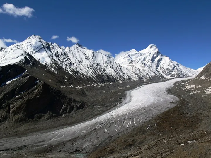
Unwinding beneath your boots is a 23-kilometer (14-mile) river of solid white ice, heavily scored with deep transverse crevasses, turquoise meltwater lakes, and dark ridges of lateral and medial moraine. Cascading steeply from the northeastern snowfields of the Doda mountain massif (peaking at 6,550 meters), Drang Drung curves gracefully like a sleeping mythical dragon through the jagged gorge, terminating at its glacial snout where milky, roaring torrents birth the Doda (Stod) River.
Ranked as the largest and longest accessible glacier in Ladakh outside the restricted military territory of Siachen, Drang Drung is uniquely accessible to adventure motorcyclists. While most Himalayan glaciers of this magnitude require multi-day high-altitude treks across remote wilderness, Drang Drung can be admired in its full panoramic splendor right from the roadside shoulder of National Highway 301 (NH301).
For motorcyclists who choose Ride & Fire Rentals for their trans-Himalayan journeys, reaching this viewpoint represents the triumphant climax of the grueling overland trek across the Suru Valley. It is the geographic and emotional gateway to Zanskar, where the sheer raw power of Himalayan ice humbles every traveler who stands beside its rim.
THE ROAR OF SHIFTING ICE: If you switch off your motorcycle engine and stand quietly in the thin air, the silence of the pass is periodically shattered by a deep, resonant rumble like distant thunder. These acoustic booms are internal ice quakes - the physical sound of millions of tons of dense glacial ice fracturing and flowing down the granite bedrock under immense gravitational pressure. It is a spine-tingling sensory reminder that you are observing a living, dynamic geological force.
Glaciology & The Birth of the Stod River: The Hydrological Engine of Zanskar
Answer-First Summary: Understanding how 23 km of moving ice feeds the famous Chadar frozen river and the Indus system.
Drang Drung Glacier is not merely a scenic spectacle; it is the vital hydrological lifeblood of the entire Zanskar and Indus river basins.
THE SOURCE OF THE DODA RIVER: The snout of Drang Drung Glacier releases enormous volumes of pressurized sub-glacial meltwater, forming the initial headwaters of the Stod River (also known locally as the Doda River). Flowing southeast for 75 kilometers through a broad gravel valley, the Stod converges at Padum with the Tsarap Chu (originating from near Baralacha La) to form the mighty Zanskar River.
THE CHADAR WINTER ICE ENGINE: In the depths of winter (January and February), the meltwaters originating from Drang Drung flow down the deep vertical gorge of the Zanskar River toward Chilling and Nimu. As ambient temperatures plummet to -35°C, the surface freezes into the legendary ice sheet known across the globe as the Chadar Trek. Without the continuous glacial discharge of Drang Drung, the unique hydrology of Zanskar would cease to exist.
GLACIAL MORAINES & RETREAT PATTERNS: Glaciologists studying Drang Drung have documented three prominent medial moraines running like dark highway dividing lines along the center of the glacier. These dark stripes consist of shattered slate and granite ground away from mountain ridges kilometers upstream. Like most Himalayan glaciers, Drang Drung is gradually retreating due to climate shifts, forming a series of expanding pro-glacial lakes at its snout.
ANCIENT ICE CORES & PALEOCLIMATE ARCHIVES: The deepest layers of ice preserved near the bottom of Drang Drung fell as snow centuries ago, during the Little Ice Age. Scientists from the National Centre for Polar and Ocean Research (NCPOR) have drilled ice cores here to analyze trapped atmospheric gases, revealing historical shifts in the Indian summer monsoon and trans-Himalayan weather patterns.
Summit Geography of Pensi La: The Gateway to the Kingdom of Zanskar
Answer-First Summary: Navigating the 14,436-foot divide between the Suru Valley and the Zanskar plateau.
The viewpoint for Drang Drung Glacier sits immediately below the summit crest of Pensi La Pass, perched at an elevation of 14,436 feet (4,400 meters) above sea level.
THE CLIMATIC & CULTURAL DIVIDE: Pensi La marks the profound geographical boundary separating the high-precipitation, green Suru Valley (influenced by moist air masses from Kashmir) from the arid, rain-shadow plateau of Zanskar. Crossing this pass also represents a dramatic cultural transition: the Muslim, Dard-Shina culture of lower Suru gives way completely to the Tibetan Buddhist kingdom of Zanskar, marked by ancient chortens, mani walls, and Gelugpa monasteries.
THE TWIN SACRED TARNS: At the broad, saddle-shaped summit of Pensi La sit two pristine, mirror-like alpine lakes: Ta Tso and Lang Tso. In the calm morning hours, their still waters reflect the surrounding snow peaks and prayer flags. These high-altitude wetlands serve as vital summer breeding grounds for rare migratory birds, including bar-headed geese and Tibetan plovers.
Senior Fleet Mechanic Advice: Thin Air Throttle Modulation & High-Altitude Cold Starts
Answer-First Summary: Stanzin Dorje explains EFI mapping compensation, spark plug soot, and battery preservation at 14,436 feet.
Operating an internal combustion engine at 14,436 feet introduces severe thermodynamic challenges that require mechanical knowledge.
THE 42% AIR DENSITY DEFICIT: At Pensi La's elevation, atmospheric pressure drops to approximately 59 kPa, containing roughly 42% less oxygen per volume of air compared to sea level. Even on modern electronic fuel injected (EFI) adventure machines like the Royal Enfield Himalayan 450, peak engine output decreases by nearly 35%. Downshifting to 1st or 2nd gear on steep switchbacks is mandatory; attempting to lug the engine in 3rd gear will cause severe engine knocking, rapid cylinder head overheating, and sudden stallouts.
COLD-START BATTERY DROP IN SUB-ZERO WINDS: Summit winds at Pensi La can plunge windchill temperatures below -5°C even during sunny afternoons. Low ambient temperatures decrease lithium and lead-acid battery cranking amperage by up to 40%. When restarting your bike after photographing the glacier, turn on the ignition, wait 5 seconds for the fuel pump to prime fully, and fire the starter button without cracking the throttle open. Cracking the throttle on EFI engines floods the cylinder with excess fuel, fouling spark plugs in the thin air.
ENGINE BRAKING ON THE DESCENT INTO ZANSKAR: Leaving the viewpoint heading toward Padum, the road drops steadily down the Doda Valley. Avoid riding your rear brake pedal continuously down these switchbacks. Shift into 2nd gear, release the clutch smoothly, and let engine compression regulate your descending speed, preserving your brake fluid from boiling.
Photography Perspectives: Golden Hour Light & Panorama Framing
Answer-First Summary: How to capture the scale, ice texture, and crevasses of Drang Drung Glacier.
Drang Drung Glacier is universally recognized as one of the most photogenic natural landscapes in the entire Himalayas.
THE IDEAL MORNING SHOOTING WINDOW: The absolute best photographic lighting occurs between 07:30 AM and 10:30 AM. During these early hours, the morning sun rises directly over the Zanskar range, illuminating the textured lateral crevasses and cast-blue ice walls with raking sidelight, creating dramatic shadows that emphasize the glacier's immense three-dimensional relief.
MIDDAY WASH-OUT & DUST HAZE: By midday, high overhead solar radiation washes out the delicate color variations between white ice and black moraine rock. Furthermore, afternoon thermal winds stir up fine silt dust across the Doda Valley, reducing optical clarity across the 23-kilometer vista.
FRAMING THE HIGHWAY & MOTORCYCLE: For iconic adventure motorcycle photographs, position your machine on the wide gravel shoulder just south of the main viewpoint chorten. Frame the shot with your motorcycle's front wheel in the foreground, using a wide-angle lens (16mm to 24mm equivalent) to capture the curving arc of the glacier sweeping into the distance behind your machine.
Extreme Altitude & Wind Chill: Staying Safe on Pensi La
Answer-First Summary: Managing hypothermia, acute mountain sickness, and high-velocity wind buffeting.
At over 14,400 feet, the Drang Drung Glacier viewpoint exposes travelers to severe physiological and environmental stresses.
RAPID ONSET OF HYPOTHERMIA: Even on bright sunny days, biting arctic winds funneled across the glacier can induce rapid body heat loss. Never stand at the viewpoint wearing only light mesh summer riding gear. Before cresting Pensi La, pull over and zip in your windproof waterproof liners, wear thermal balaclavas under your helmet, and slip on insulated windproof riding gloves.
MANAGING HYPOXEMIA & DIZZINESS: If you spent the previous night in Kargil (8,780 ft) and rushed directly to Pensi La in a single day, you have ascended over 5,600 vertical feet. Mild hypoxia symptoms - including pulsing temple pain, nausea, and shortness of breath - are extremely common. Limit your walking around the viewpoint to slow, measured steps, and avoid scrambling down the steep moraine cliffs toward the ice.
THE 30-MINUTE SUMMIT RULE: In high-altitude adventure motorcycling, we enforce the 30-Minute Rule: unless you are acclimatized through weeks in Ladakh, never linger at pass summits above 14,000 feet for more than half an hour. Capture your photographs, marvel at the ancient ice, and begin your descent into the sheltered, lower elevation of the Doda Valley.
Senior Fleet Mechanic's 5-Point Summit Shakedown Checklist
Answer-First Summary: Stanzin Dorje's quick inspection before beginning the descent toward Padum.
Before putting your motorcycle in gear to descend into Zanskar, spend two minutes performing this essential summit safety check:
1. BRAKE LEVER PRESSURE CONFIRMATION: Pump both the front brake lever and rear brake pedal several times while stationary. Ensure firm hydraulic resistance is present before engaging downhill gears.
2. TIRE PRESSURE INTEGRITY: Inspect both tires for visible punctures caused by sharp shale shards on the climb. Cold summit temperatures cause tire pressures to drop slightly; maintain 22 PSI front and 32 PSI rear.
3. RADIATOR CAP & HOSE INTEGRITY: Glance behind your front forks to verify no coolant is weeping from radiator hose clamps after the strenuous, low-gear climb up Pensi La.
4. LUGGAGE STRAP TENSION: The violent washboard vibrations of the Pensi La ascent loosen bungee cords and webbing straps. Pull all luggage cinch straps tight to ensure your tailbag does not shift over your rear fender.
5. HEADLIGHT & AUXILIARY LAMPS: Confirm your headlight is shining brightly. Dust kicked up by oncoming BRO road machinery can obscure light lenses; wipe your headlight with a rag to ensure maximum visibility.
Forward Route to Padum: Down the Doda Valley into Central Zanskar
Answer-First Summary: Navigating the 75 km descent through Abran, Aksho, and the fertile fields of Padum.
From the Drang Drung viewpoint, the road begins its long, scenic descent into the heart of Zanskar along the newly designated NH301 corridor.
THE DODA VALLEY ROUTE: The highway drops steadily along the northern bank of the newly formed Stod River, passing the traditional Buddhist farming hamlets of Abran, Aksho, and Tungri. The road gradually widens as you descend, transitioning between sections of fresh BRO double-lane tarmac and stretches of hard-packed gravel.
LOWER ALTITUDE RECOVERY IN PADUM: After 75 kilometers of descending riding, you reach the commercial capital of Zanskar: Padum, sitting at a much milder 11,998 feet (3,657 m). Padum offers full phone connectivity (Jio/Airtel 4G), hotels, homestays, mechanic workshops, and the sole commercial IOCL petrol station in the entire Zanskar region.
THE ZANSKAR CIRCUIT CONNECTION: From Padum, adventurous riders can continue south across the mighty Shinku La pass (16,580 ft) into Himachal Pradesh, or ride the newly opened river road north through Zangla and Chilling to loop directly back into Leh.
Visiting Logistics, Timing & Environmental Preservation Protocols
Answer-First Summary: Best travel seasons, zero permit requirements, wilderness protection, and zero-trace ethics.
Experiencing Drang Drung Glacier is a privilege that comes with environmental responsibilities.
BEST TIME OF YEAR: The optimal window to visit Drang Drung Glacier is between mid-June and late September. During this period, Pensi La is free of deep snow, road crossings are manageable, and daytime temperatures remain comfortable for riding.
ZERO ADMISSION FEES & PERMIT CHECKS: The glacier viewpoint is a natural roadside scenic overlook; there are no commercial admission charges or ticket gates. Ensure you keep your Inner Line Permit (ILP) handy for the police checkposts at Rangdum and Padum.
STRICT LEAVE-NO-TRACE ETHICS: The fragile alpine ecosystem of Pensi La has no municipal waste collection. Never discard plastic bottles, snack wrappers, or oil cans at the viewpoint. Pack all waste securely on your motorcycle and dispose of it properly in Padum or Kargil.
DO NOT ATTEMPT TO WALK ONTO THE GLACIER: The distance from the roadside viewpoint down to the glacier snout appears deceivingly short (less than 1 km in straight-line sight), but involves descending treacherous 45-degree scree slopes of razor-sharp shale. Furthermore, active crevasses, shifting seracs, and invisible snow bridges make walking on the glacier without technical crampons, ice axes, and ropes exceptionally hazardous.
Route Milestones, Elevation & Road Conditions
| Milestone / Location | Elevation (ft / m) | Distance from Kargil | Key Facilities & Route Telemetry |
|---|---|---|---|
| Rangdum Monastery Staging Base | 11,998 ft / 3,657 m | 130 km | Last homestay settlement, basic food, police checkpoint. |
| Juldo Village & Valley Turn | 12,200 ft / 3,719 m | 136 km | Nomadic grazing pastures, small river ford crossings. |
| Pensi La Switchback Ascent | 13,200 ft / 4,023 m | 146 km | Steep gravel switchbacks, loose scree, Project VIJAYAK work. |
| Ta Tso & Lang Tso Lakes | 14,350 ft / 4,374 m | 154 km | Pristine twin alpine tarns, waterfowl habitat, chortens. |
| Pensi La Pass Summit Crest | 14,436 ft / 4,400 m | 155 km | Highest point on NH301, prayer flags, wind tunnel. |
| Drang Drung Glacier Viewpoint | 14,300 ft / 4,359 m | 156.5 km | Iconic roadside turnout, panoramic 23 km white ice vista. |
| Abran Village Outskirts | 12,800 ft / 3,901 m | 180 km | First permanent Zanskari village, barley fields, homestays. |
| Tungri Monastery Turnoff | 12,300 ft / 3,749 m | 205 km | Historic Gelugpa gompa on rocky spur, Doda river bridge. |
| Padum Town Center (IOCL Bunk) | 11,998 ft / 3,657 m | 230 km | Zanskar capital, petrol pump, 4G mobile, hotels, workshops. |
Ready for Your Ladakh Motorcycle Adventure?
Navigating the complex checkpoints and steep elevations of UT Ladakh requires both legal compliance and mechanical reliability. At Ride & Fire Rentals, we offer locally registered motorcycles with the mandatory LA-02 yellow commercial plates, ensuring you clear every military and union checkpoint seamlessly. Our fleet is 100% fuel-injected and thoroughly checked before every handover at our Changspa Road workshop.
For external travel planning references, you can check the official Ladakh Tourism Portal or apply for permits via the LAHDC Leh Permit Portal.
Season Launch Offer
Book your motorcycle direct from our Changspa Road facility. Get a standard 25% direct booking discount, plus enter coupon code LADAKH5 at checkout for an extra 5% off (saving nearly 30% total) on your entire rental! This promotion is active until June 30.
Frequently Asked Questions
Where is Drang Drung Glacier located and how do I reach it? +
Drang Drung Glacier is located just 1.5 km past the summit of Pensi La (14,436 ft / 4,400 m) along National Highway 301 (NH301) connecting Kargil and Padum. It is located 156.5 km southeast of Kargil and 74 km northwest of Padum, offering a direct panoramic view right from the roadside.
How long is Drang Drung Glacier and why is it important? +
Drang Drung Glacier stretches approximately 23 kilometers (14 miles), making it the second longest glacier in Ladakh after Siachen. It is the primary hydrological source of the Doda (Stod) River, which merges with the Tsarap Chu at Padum to form the Zanskar River.
Can I walk onto Drang Drung Glacier from the road? +
No. Descending from the road down to the glacier involves scrambling down treacherous, loose scree slopes. Walking on the glacier itself without mountaineering equipment (crampons, ropes, harnesses) is extremely dangerous due to hidden crevasses, unstable seracs, and falling ice.
What are the road conditions around Pensi La and Drang Drung Glacier? +
The road over Pensi La is unpaved, featuring gravel, loose stones, corrugations, and seasonal mud ruts from melting snow. BRO Project VIJAYAK is actively working to widen and pave NH301, but adventure motorcycles with dual-sport tires and ample ground clearance are recommended.
What is the best time of day to photograph Drang Drung Glacier? +
The best time is early morning between 07:30 AM and 10:30 AM, when low-angled raking sunlight highlights the white ice ridges, crevasses, and blue meltwater pools with deep contrasting shadows. Afternoon sun washes out the scene and brings high winds.
Is there mobile phone network at Pensi La or Drang Drung Glacier? +
No. There is no mobile cellular network coverage (Jio, Airtel, BSNL) at Pensi La or Drang Drung Glacier. The nearest connectivity is in Padum (74 km south) or Panikhar (90 km north).
Do I need an Inner Line Permit (ILP) to visit Drang Drung Glacier? +
Yes. Indian domestic tourists require an Inner Line Permit (ILP) and foreign nationals require a Protected Area Permit (PAP) to travel through this sector, which are verified at the police checkpoints in Rangdum and Padum.