
Quick Summary: What makes Rangdum Monastery one of the most dramatic and remote outposts in Ladakh?
Quick Answer: Perched on a solitary, wind-swept earthen rock knoll rising from the vast braided alluvial riverbed of upper Suru Valley at 11,998 ft (3,657 m), Rangdum Monastery is an 18th-century Gelugpa fortress founded by Lama Gelek Yashy Takpa. Located 130 km southeast of Kargil along the rugged, partially unpaved NH301 corridor, it stands as the final monastic sanctuary and staging post before crossing the high glaciated barrier of Pensi La into Zanskar, surrounded by bifurcated river branches, nomadic pastures, and zero commercial cell towers.
The Solitary Fortress on the Riverbed: Introducing Rangdum Gompa
Answer-First Summary: Discovering the dramatic isolation, sweeping valley floor, and fortress architecture of upper Suru.
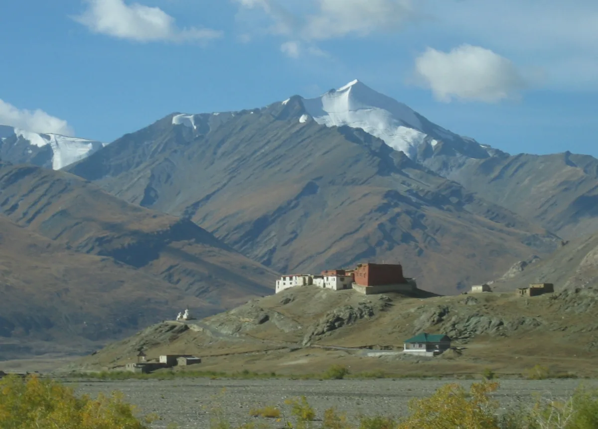
Few sights in the trans-Himalayan realm evoke a deeper sense of geographic isolation and untamed wilderness than the first glimpse of Rangdum Monastery. As adventure motorcyclists battle their way southeast from Kargil along the rugged, dust-scoured corridor of National Highway 301 (NH301), the narrow agricultural terraces of lower Suru Valley gradually surrender to a vast, treeless amphitheater flanked by serrated glacial massifs. Here, at an elevation of 11,998 feet (3,657 meters), the braided Suru River splits into a dozen glistening gravel channels spanning a mile-wide valley floor.
Rising defiantly from the center of this flat alluvial plain like a solitary granite island in a sea of stone and ice is a steep-sided knoll crowned by the whitewashed ramparts of Rangdum Gompa. Resembling a medieval frontier castle far more than a conventional monastic retreat, Rangdum was deliberately constructed as a fortified sanctuary capable of enduring both the brutal trans-Himalayan winter blizzards and historical border raids by Balti and Dogra warriors.
Founded in the 18th century during the reign of King Tsewang Namgyal of Ladakh by Lama Gelek Yashy Takpa, Rangdum belongs to the Gelugpa (Yellow Hat) order of Tibetan Buddhism. It houses approximately 30 to 40 monks and supports a small community of novice lamas who live in almost total isolation from the outside world for eight months of the year when winter snowpacks seal the passes.
For motorcyclists embarking on long-range expeditions with Ride & Fire Rentals, reaching Rangdum marks the transition from civilized Ladakh into the raw, unforgiving frontier of Zanskar. It is the mandatory halfway staging post where riders refuel their bodies, inspect their machinery, and acclimatize before ascending toward the glaciated summit of Pensi La.
THE SENTINEL OF TWO EMPIRES: Historically, Rangdum marked the border between the Muslim-majority chieftains of Purig (modern Kargil) and the deeply Buddhist Himalayan kingdom of Zanskar. Standing watch over the caravan route that traded salt from the high Changthang lakes for barley from Kashmir, the monastery's lamas maintained spiritual alliances across the high passes while offering sanctuary to merchant caravans trapped by unseasonal autumn blizzards.
History & Sacred Relics: The Fortress of Lama Gelek Yashy Takpa
Answer-First Summary: Exploring the ancient assembly hall, tantric thangkas, and defensive walls of the 18th-century complex.
The architectural layout of Rangdum reflects its dual purpose as a spiritual sanctuary and a fortified defensive citadel.
THE FORTIFIED WALLS & RAMPARTS: The monastery's perimeter consists of towering stone-and-mud walls that follow the contours of the natural rock mound. Entry is gained through a single narrow, heavy timber gate reached via an inclined stone ramp that could be easily defended against mounted intruders. The outer walls are punctuated by tiny defensive arrow slits and vertical observation windows overlooking the entire valley floor.
THE DUKHANG & ANCIENT ARTIFACTS: Inside the dimly lit Dukhang (main assembly hall), centuries of smoldering yak-butter lamps have cast a rich, dark patina over the carved wooden pillars and silk thangkas. The central altar houses impressive gilded statues of Gautama Buddha, Tsongkhapa (founder of the Gelugpa order), and the wrathful protector deity Yamantaka. Displayed along the walls are antique Tibetan weapons - including matchlocks, daggers, and iron shields - offered to the monastery by warriors seeking divine protection before battle.
THE COLLECTION OF RARE MANUSCRIPTS: Rangdum preserves a precious collection of rare hand-lettered Buddhist scriptures, ritual mask collections used in the annual cham dances, and antique copper tea cauldrons large enough to brew butter tea for a hundred lamas during winter festivals.
THE MONASTIC SCHOOL: Within the monastery courtyard, young novice monks (trapas) study Buddhist philosophy, Tibetan grammar, and memorization of tantric rituals, maintaining a centuries-old spiritual tradition in one of the harshest inhabited environments in Asia.
Wild Upper Suru Geography: Braided Rivers, Marmots & Nomadic Herders
Answer-First Summary: Immersing in the dramatic natural terrain where the Greater Himalayas meet the Zanskar range.
The physical environment surrounding Rangdum is unlike any other valley in UT Ladakh.
THE BRAIDED RIVER PLAIN: For ten kilometers before and after the monastery, the Suru River transforms into an expansive braided channel network. In summer, glacial meltwaters from the surrounding peaks turn the valley floor into a labyrinth of cold, rushing streams, marshy meadows, and gravel islands. Flocks of migratory bar-headed geese, brahminy ducks, and black-necked cranes feed in the shallow wetlands alongside herds of domestic yaks and dzo.
THE COLONY OF HIMALAYAN MARMOTS: The grassy banks of the valley floor are honeycombed with burrows belonging to hundreds of golden Himalayan marmots. These oversized alpine rodents emerge in the summer sun, standing upright on their hind legs and whistling sharp warning cries to alert their colonies as motorcycle engines echo across the valley.
BAKARWAL AND CHANGPA NOMADS: During July and August, nomadic Gujjar and Bakarwal pastoralists from Jammu and Kashmir pitch their low, dark goat-hair tents along the river terraces, grazing vast herds of sheep and pashmina goats on the nutritious alpine grasses before winter forces them southward across the Pir Panjal.
NH301 Kargil-to-Padum Highway: Road Status, Washboard & Unpaved Realities
Answer-First Summary: Real-world telemetry, surface hazards, BRO Project VIJAYAK paving progress, and river washes.
Riding to Rangdum is a true test of machine reliability and rider endurance along National Highway 301 (NH301).
PAVING PROGRESS VS. UNPAVED CORRUGATIONS: Border Roads Organisation (BRO) Project VIJAYAK is actively double-laning NH301 between Kargil and Padum. As of 2026, the road is smoothly paved from Kargil through Sankoo and Panikhar up to Parkachik (km 85). However, the 45-kilometer stretch from Parkachik to Rangdum remains largely unpaved, consisting of hard-packed dirt, severe corrugated washboard sections, and loose fist-sized river scree.
THE INFAMOUS WASHBOARD VIBRATION: Corrugated washboard terrain is brutal on both rider and motorcycle. Riding too slowly (under 25 km/h) causes the front wheel to plunge into every individual trough, transferring violent shockwaves into the handlebars and rider's shoulders. Experienced adventure riders stand on their footpegs, clamp the tank with their knees, and maintain a brisk 40 to 50 km/h cruising pace to skim across the crests of the corrugations, letting the suspension absorb the impacts.
GLACIAL RUNOFF WATER CROSSINGS: Several unbridged mountain streams cross NH301 between Parkachik and Rangdum. While calm and shallow in the early morning (less than 6 inches deep), high afternoon temperatures accelerate glacial melting, turning these fords into swift, knee-deep torrents carrying rolling boulders by 03:00 PM. Always plan your ride to clear these crossings before midday.
Senior Fleet Mechanic Advice: Suspension Preload, Spoke Tension & Chain Hygiene
Answer-First Summary: Stanzin Dorje explains how the violent vibrations of NH301 impact chassis fasteners, wheel rims, and air intake.
At Ride & Fire Rentals, the Kargil-Zanskar route is our benchmark torture test for rental machinery. Preparing your bike for Rangdum requires specific mechanical precautions.
SPOKE WHEEL TENSION & RIM TRUING: The relentless hammering of corrugated rock on NH301 will rapidly loosen wire-spoked wheels. Before leaving Kargil, take an 8mm spoke wrench (or tap each spoke with a small wrench handle). A properly tensioned spoke rings with a clear, high-pitched ping; a loose spoke produces a dull, hollow thud. Riding on loose spokes over unpaved washboard causes rapid rim deformation and spoke breakage.
FASTENER SECURITY & BOLT RETIGHTENING: High-frequency vibrations will back out unsecured bolts. Pay special attention to your motorcycle's handlebar clamps, footpeg mounting bolts, exhaust header nuts, and luggage rack mounts. Check all critical chassis fasteners every evening when you reach Rangdum.
SUSPENSION PRELOAD ADJUSTMENT FOR UNPAVED TRACKS: On modern adventure bikes like the Royal Enfield Himalayan 450, increase your rear monoshock preload by 2 notches before hitting the unpaved gravel of upper Suru. This preserves essential ground clearance, preventing the engine bash plate from smashing against jagged rocks during deep suspension compression.
AIR FILTER FOULING IN SURU DUST: Upper Suru Valley is notoriously windy, whipping up thick clouds of silt-fine dust. If riding in a group, maintain a minimum 100-meter following distance to avoid sucking your partner's dust plume directly into your intake snorkel.
Fuel Logistics & The Zero-Pump Void: The 230 km Kargil-to-Padum Mathematics
Answer-First Summary: Managing fuel range, auxiliary jerry cans, and fuel burn calculations across the passes.
The single most dangerous logistical error an adventure rider can make on the Zanskar circuit is underestimating fuel consumption.
THE 230-KILOMETER ZERO-FUEL VOID: There are NO commercial petrol stations between Kargil and Padum. The last Indian Oil (IOCL) petrol pump is located on the southern outskirts of Kargil town (km 0). The next commercial petrol pump is the IOCL station in Padum (km 230). Rangdum sits right in the middle at km 130.
ROUGH ROAD CONSUMPTION FACTOR: On smooth asphalt, a Royal Enfield Himalayan 450 easily delivers 30 to 32 km/liter, giving its 17-liter fuel tank a theoretical range of over 500 km. However, on the unpaved washboard, river crossings, and sustained 2nd-gear climbs of NH301, fuel consumption spikes dramatically to 20 to 22 km/liter. Fighting strong head winds across upper Suru drains tanks even faster.
MANDATORY FUEL RESERVE: Never attempt this route without at least 5 liters of auxiliary fuel carried in certified Jerry cans mounted securely to your pannier racks. In Rangdum village, local homestays and dhabas occasionally sell black-market petrol dispensed from plastic barrels at ₹150 to ₹180 per liter; however, this fuel is frequently adulterated with kerosene or contaminated with water and sediment that will instantly clog modern high-pressure EFI fuel pumps.
Extreme Remote Living: Zero Cell Coverage, Off-Grid Solar & Homestay Realities
Answer-First Summary: What to expect from Rangdum's rustic accommodation, food, electricity, and communications.
Visiting Rangdum requires travelers to adjust their expectations regarding modern amenities.
ZERO CELLULAR NETWORK: As of 2026, there is absolutely NO mobile cellular coverage in Rangdum - neither Jio, Airtel, nor BSNL provides mobile reception. Once you pass Panikhar (km 65 from Kargil), your smartphone becomes purely a camera and offline GPS tool. The nearest emergency communication is an Indian Army satellite phone post located near the monastery.
OFF-GRID SOLAR ELECTRICITY: Rangdum has no connection to the national power grid. The small settlement of homestays and the monastery rely entirely on rooftop solar panels and battery banks. Electricity is typically available for only 2 to 3 hours in the evening (from 07:30 PM to 10:00 PM) to power basic LED lights. Charge your camera batteries, power banks, and headlamps immediately upon arrival.
RUSTIC HOMESTAYS & MONASTERY GUESTHOUSE: Accommodation in Rangdum consists of basic family-run homestays and a modest guesthouse run by the monastery. Expect traditional shared dry Ladakhi compost toilets, thick yak-wool blankets, bucket hot water heated on wood-fired bukhari stoves, and hearty, wholesome meals of dal-chawal, hot thukpa, and butter tea.
Weather Hazards & Evening Temperature Inversions: The Pensi La Gateway
Answer-First Summary: Surviving sub-zero nocturnal freezes, ferocious valley winds, and rapid weather shifts.
At nearly 12,000 feet, nestled beneath the glaciated northern walls of the Greater Himalayas, Rangdum experiences intense and unpredictable weather patterns.
FEROCIOUS CANYON WIND TUNNEL: From midday until sunset, cold katabatic winds tumble down from the glaciated crests of Mount Nun (7,135 m) and Kun (7,077 m), funneling down the Suru canyon with sustained gusts of 40 to 60 km/h. Motorcyclists riding lightweight machines will experience sharp lateral buffeting. Grip the fuel tank firmly and lower your cruising speed to stay in control.
SUB-ZERO NIGHT TEMPERATURES: Even during the peak summer months of July and August, nighttime temperatures in Rangdum routinely drop between 0°C and -4°C. By late September, freezes reach -10°C. Cold morning temperatures turn engine oil sluggish and drain lithium-ion phone and action-camera batteries within minutes. Keep your electronic devices and spare camera batteries inside your sleeping bag overnight to keep them warm.
RAPID BLIZZARD INFILTRATION: Because Rangdum sits near the summit pass of Pensi La Pass, weather fronts from the Kashmir Valley can spill over the pass without warning, bringing heavy rain or unseasonal snow even in mid-summer.
Senior Fleet Mechanic's 5-Point Rangdum Evening Maintenance Routine
Answer-First Summary: Stanzin Dorje's mandatory evening checklist before heading toward Zanskar.
When you arrive at Rangdum after 130 km of brutal unpaved roads, your motorcycle demands immediate care before you rest:
1. DRIVE CHAIN INSPECTION & WAXING: Clean off heavy Suru gravel dust with a rag and apply a thick coating of dry wax chain lubricant while the chain is still warm from the ride. Inspect chain tension; unpaved washboard frequently causes drive chains to stretch beyond 35mm of slack.
2. ENGINE BASH PLATE & OIL SUMP CHECK: Crawl underneath the machine with a flashlight. Inspect the aluminum bash plate and engine oil drain bolt for signs of impact or fresh oil weeping caused by flying scree.
3. TIRE PRESSURE CHECK ON COOL RUBBER: Inspect tire treads for sharp slate shards wedged between rubber blocks. Maintain 22 PSI front and 32 PSI rear cold pressures.
4. REAR SUSPENSION LINKAGE & FORK SEALS: Wipe down both front fork stanchions with a clean micro-fiber cloth to remove dried mud crusts that can tear rubber fork seals on the next day's ride.
5. FUEL LEVEL VERIFICATION: Check your remaining tank volume. Calculate your fuel math to ensure you have at least 8 to 10 liters remaining to conquer Pensi La and complete the remaining 100 km descent to Padum.
Visiting Logistics, Timings & Continuing over Pensi La into Zanskar
Answer-First Summary: Monastery visiting hours, nominal donations, staging for Drang Drung Glacier, and permit checks.
Planning your visit to Rangdum and coordinating your forward journey over Pensi La is vital for a safe expedition.
MONASTERY ENTRY & PUJA HOURS: Rangdum Monastery is open to respectful visitors daily from 06:00 AM to 07:00 PM. The morning prayer puja begins at 06:30 AM and is an unforgettable spiritual experience to witness before packing your motorcycle. A nominal entry contribution of ₹50 is customary at the Dukhang entrance.
CHECKPOINT & PERMIT PROTOCOLS: There is a Jammu and Kashmir Police / Ladakh Police checkpoint at the entrance to Rangdum village. Riders must present their driver's licenses, motorcycle registration papers, and Inner Line Permits (ILP) for domestic travelers or Protected Area Permits (PAP) for foreign nationals.
STAGING FOR DRANG DRUNG GLACIER: Rangdum is the ideal base to tackle Pensi La (14,436 ft). Departing Rangdum by 07:30 AM allows you to reach the summit pass and the breathtaking vista of Drang Drung Glacier by 09:00 AM, enjoying crystal-clear morning sunlight, minimal wind, and frozen stream crossings before afternoon meltwaters rise.
Route Milestones, Elevation & Road Conditions
| Milestone / Location | Elevation (ft / m) | Distance from Kargil | Key Facilities & Route Telemetry |
|---|---|---|---|
| Kargil City Base (IOCL Bunk) | 8,780 ft / 2,676 m | 0 km | Last commercial petrol station, ATMs, full mechanic shops. |
| Sankoo Village Oasis | 9,800 ft / 2,987 m | 42 km | Paved double-lane tarmac, medical clinic, restaurants, fruit stalls. |
| Panikhar (Nun-Kun Viewpoint) | 10,200 ft / 3,109 m | 65 km | Magnificent views of Mount Nun (7,135 m) and Kun (7,077 m). |
| Parkachik (Tarmac Ends) | 11,000 ft / 3,353 m | 85 km | Paved road ends; rough dirt, washboard, and gravel begin. |
| Parkachik Glacier Viewpoint | 11,200 ft / 3,414 m | 88 km | Stunning hanging glacier view, suspension bridge across Suru. |
| Rangdum Police Checkpoint | 11,950 ft / 3,642 m | 128 km | Document registration, police post, satellite phone point. |
| Rangdum Village Settlement | 11,980 ft / 3,651 m | 130 km | Basic homestays, dhabas, solar power, emergency barrel fuel. |
| Rangdum Monastery Gate | 11,998 ft / 3,657 m | 132 km | 18th-century Gelugpa citadel, Dukhang, ancient armor relics. |
| Pensi La Pass Summit | 14,436 ft / 4,400 m | 155 km | Gateway to Zanskar, twin alpine lakes, Drang Drung Glacier viewpoint. |
Ready for Your Ladakh Motorcycle Adventure?
Navigating the complex checkpoints and steep elevations of UT Ladakh requires both legal compliance and mechanical reliability. At Ride & Fire Rentals, we offer locally registered motorcycles with the mandatory LA-02 yellow commercial plates, ensuring you clear every military and union checkpoint seamlessly. Our fleet is 100% fuel-injected and thoroughly checked before every handover at our Changspa Road workshop.
For external travel planning references, you can check the official Ladakh Tourism Portal or apply for permits via the LAHDC Leh Permit Portal.
Season Launch Offer
Book your motorcycle direct from our Changspa Road facility. Get a standard 25% direct booking discount, plus enter coupon code LADAKH5 at checkout for an extra 5% off (saving nearly 30% total) on your entire rental! This promotion is active until June 30.
Frequently Asked Questions
How far is Rangdum from Kargil and how long does the motorcycle ride take? +
Rangdum is located 130 km southeast of Kargil along NH301. Although 130 km seems short, the journey takes between 5 and 7 hours by motorcycle because the road past Parkachik (last 45 km) is unpaved, consisting of heavy washboard corrugations, gravel, and glacial stream crossings.
Is there a petrol pump in Rangdum or Suru Valley? +
No. There are no commercial petrol pumps in Rangdum or anywhere between Kargil and Padum (a 230 km fuel void). The last official fuel station is in Kargil. Carrying at least 5 liters of auxiliary fuel in certified jerry cans is mandatory.
Is there mobile phone network or internet in Rangdum? +
No. There is no mobile cellular network coverage (neither Jio, Airtel, nor BSNL) in Rangdum as of 2026. Connectivity cuts off past Panikhar. Emergency communication is limited to an Indian Army satellite phone post.
What kind of accommodation is available in Rangdum? +
Accommodation in Rangdum is rustic and consists of basic family-run homestays and a modest monastery guesthouse. Facilities include shared dry Ladakhi compost toilets, solar-powered lighting for 2 to 3 hours in the evening, wood-heated bucket water, and simple vegetarian meals.
Do I need an Inner Line Permit (ILP) to visit Rangdum and Zanskar? +
Yes. Indian domestic tourists require an Inner Line Permit (ILP) and foreign nationals require a Protected Area Permit (PAP) to travel past the police checkpoint at Rangdum toward Pensi La and Zanskar.
How cold does it get in Rangdum at night? +
Because Rangdum sits at nearly 12,000 feet surrounded by glaciers, night temperatures routinely dip to 0°C to -4°C even in peak summer (July and August), and can drop below -10°C in September and October. Warm thermal layers are essential.
What are the road conditions between Parkachik and Rangdum? +
The 45 km stretch between Parkachik and Rangdum is unpaved, featuring severe washboard corrugations, loose fist-sized stones, and several unbridged glacial meltwater streams that swell in the afternoon. Stand on the footpegs and maintain a steady 40 km/h pace to glide over corrugations.