
Quick Summary: What makes Parkachik Glacier one of the most spectacular glacial spectacles in Ladakh?
Quick Answer: Plunging from the towering 7,000-meter north face of the Nun-Kun massif directly into the narrow gorge of the Suru River at 11,000 ft (3,353 m), Parkachik Glacier is a massive hanging icefall characterized by towering azure-blue seracs, active calving ice cliffs, and raw glacial moraines. Located 85 km southeast of Kargil along NH301, it marks the dramatic physical frontier where smooth double-lane bitumen ends and the rugged unpaved wilderness of upper Suru and Zanskar begins.
The Cascading Icefall of Nun: Introducing Parkachik Glacier
Answer-First Summary: Witnessing the sheer vertical drop of hanging ice, seracs, and terminal moraines above the Suru River.
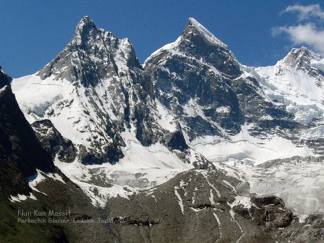
As adventure motorcyclists journey deeper into the Suru Valley along National Highway 301 (NH301), leaving the emerald willow fields of Panikhar behind, the valley walls constrict dramatically into a steep, shadowed granite canyon. At km 85 from Kargil, the road rounds an exposed cliffside bend at an elevation of 11,000 feet (3,353 meters), and riders are confronted with one of the most visually violent, raw displays of glacial mechanics in the Himalayas: Parkachik Glacier.
Spilling down from the colossal northern icefields of Mount Nun (7,135 m) and Pinnacle Peak, Parkachik Glacier does not meander gently like the broad valley glaciers of Changthang. Instead, it is a precipitous hanging glacier that cascades over a steep rock terrace, tumbling nearly 3,000 vertical meters toward the valley floor. The glacier terminates in an immense, fractured icefall where colossal seracs - some as tall as five-story buildings - lean precarious out over dark granite slabs before calving down into the roaring grey torrent of the Suru River.
The auditory impact of Parkachik Glacier is as overwhelming as its visual scale. Throughout the day, the canyon echoes with explosive cracks and groans as the ice fractures under immense gravitational shear. Massive blocks of ice periodically shear away, triggering localized ice avalanches that crash onto the terminal moraine with sounds resembling heavy artillery fire, sending plumes of ice dust swirling over the river canyon.
For riders mounting dual-sport machines with Ride & Fire Rentals, Parkachik is a profound geographical milestone. It is not merely a breathtaking natural amphitheater, but the defining frontier on the trans-Himalayan route - the exact point where the smooth, civilized asphalt of lower Ladakh gives way to the unpaved, gravel-strewn wilderness of Zanskar.
Glaciology & Calving Dynamics: The Anatomy of a Hanging Icefall
Answer-First Summary: Examining serac formation, crevasses, thermal summer melt, and river gorge interactions.
Parkachik Glacier offers geologists and observant travelers a textbook demonstration of hanging glacier dynamics.
THE STEEP ICEFALL GEOMETRY: Glaciers are essentially slow-moving rivers of solid ice. When a glacier flows over a gradual gradient, it maintains a smooth, continuous surface. However, when the underlying bedrock drops steeply - as it does on the northern flank of Mount Nun - the brittle upper 50 meters of ice cannot stretch to accommodate the rapid flow. It shatters into a chaotic maze of intersecting transverse and longitudinal crevasses, forming the jagged, freestanding ice pinnacles known as seracs.
SOLAR THERMAL EXPANSION & CALVING: During peak summer (July and August), intense high-altitude solar radiation heats the dark rock cliffs flanking the glacier. This heat conducts into the margins of the ice, lubricating the bedrock with meltwater and accelerating the glacier's forward velocity. Calving activity reaches its peak between 12:00 PM and 04:00 PM, when thermal expansion causes unstable seracs to tumble down the face.
THE TERMINAL MORAINE RAMPART: At the foot of the icefall, the glacier has pushed up a massive embankment of pulverized granite boulders, slate scree, and glacial flour (rock flour). The Suru River has carved a narrow, churning slot directly through this moraine dam, creating ferocious rapids where milky meltwater crashes against house-sized boulders.
THE BLUE-ICE PHENOMENON: Visitors often ask why the deep interior of Parkachik's seracs appears intensely neon-blue rather than white. Surface snow appears white because air bubbles between snow crystals scatter all wavelengths of visible light equally. In deep glacial ice, hundreds of years of extreme gravitational pressure compress the ice so densely that air bubbles are eliminated. This ultra-dense ice absorbs long-wavelength red and yellow light, reflecting only high-energy blue wavelengths back to the human eye, creating an otherworldly azure luminescence.
The Historic Suspension Bridge & Base Moraine Scramble
Answer-First Summary: Crossing the roaring Suru River on timber planks and hiking the moraine ridge.
While the panoramic view of Parkachik Glacier from the NH301 highway shoulder is magnificent, adventurous riders can get dramatically closer by taking a short foot trek.
THE TIMBER SUSPENSION BRIDGE: Directly below the village of Parkachik, a traditional pedestrian suspension bridge spans the roaring Suru River. Walking across this swaying steel-cable bridge - with timber footboards groaning beneath your boots and the grey glacial torrent churning violently twenty feet below - is an exhilarating adventure in itself.
THE MORAINE RIDGE TRAIL: Across the river, a well-defined footpath ascends through stunted sea buckthorn bushes and wild rose thickets onto the lateral moraine ridge. The hike requires approximately 30 to 45 minutes of steady walking, gaining roughly 150 vertical meters.
THE CLOSE-UP ICEFALL PERSPECTIVE: Standing atop the moraine ridge, you are positioned directly opposite the lower seracs of the glacier. The sheer scale is staggering: you can look directly into the deep, luminous sapphire-blue crevasses and feel the freezing downdraft of dense katabatic air rushing off the ice. Keep a respectful distance from the active debris chutes, as flying rock fragments from collapsing seracs can carry considerable distances.
GLACIAL ROCK FLOUR & RIVER SILT: As you walk along the riverbanks, observe the peculiar pale, milky coloration of the Suru River. This unique hue is caused by 'rock flour' - microscopic silt particles generated as the massive weight of Parkachik Glacier grinds against its underlying granite bedrock. When suspended in water, these fine minerals scatter sunlight to give the river its iconic opalescent appearance.
NH301 Tarmac Transition: The End of Asphalt & The Frontier Begins
Answer-First Summary: Navigating the sharp engineering shift from BRO double-lane bitumen to unpaved wilderness.
For motorcyclists, Parkachik is famous as the 'Asphalt Divide' of the Kargil-to-Padum highway.
THE END OF THE PAVED CORRIDOR: Departing Kargil and Panikhar, riders enjoy 85 kilometers of flawless, newly laid double-lane tarmac. However, immediately after rounding the corner past Parkachik village, the smooth blacktop comes to an abrupt halt. The road transitions into an unpaved, single-track wilderness trail carved through glacial silt, loose slate scree, and corrugated river washboards.
THE 45 KM UNPAVED PUSH TO RANGDUM: From Parkachik, you face 45 kilometers of rough, demanding dirt riding to reach Rangdum Monastery. This section tests your motorcycle's suspension, chassis integrity, and your own physical endurance. Speeds drop from 60 km/h on the highway down to 25 to 35 km/h on the rough terrain.
PROJECT VIJAYAK EXPANSION HAZARDS: Border Roads Organisation (BRO) Project VIJAYAK is actively working to widen and blast the rock face between Parkachik and Rangdum. Watch for heavy bulldozers, track excavators, and temporary road blocks where blasting operations occur between 11:00 AM and 03:00 PM.
MANAGING TIRE PRESSURE TRANSITIONS: Experienced riders stop at the exact edge of the tarmac to bleed air from their tires. Dropping front tire pressure from 22 PSI to 18 PSI and rear from 32 PSI to 26 PSI gives the rubber knobs room to deform around jagged stones, absorbing impacts that would otherwise rattle steering head bearings and cause front-wheel skidding on downhill gravel.
Senior Fleet Mechanic Advice: Preparing Your Motorcycle for the Unpaved Divide
Answer-First Summary: Stanzin Dorje explains tire pressure drops, suspension adjustments, and air filter care at the transition.
At Ride & Fire Rentals, we instruct every rider embarking for Zanskar to pull over in Parkachik for a mandatory 10-minute mechanical setup transition.
LOWERING TIRE PRESSURES FOR GRAVEL TRACTION: High-speed highway tarmac requires firm pressures (22 PSI front, 32 PSI rear) to prevent tire overheating. However, hitting rough unpaved washboard and loose river rocks with hard tires will cause violent handlebar vibration and skittish front-wheel deflection. PILOT TIP: In Parkachik, drop your tire pressures down to 18 PSI front and 26 PSI rear. This enlarges your tire contact patch, allows the tread rubber to mold over sharp stones, and cushions your chassis from relentless shockwaves.
SUSPENSION PRELOAD & BASH PLATE INSPECTION: On adventure machines like the Royal Enfield Himalayan 450, verify that your rear shock preload is set appropriately for your total luggage weight. A sagging rear end lowers engine ground clearance, increasing the danger of high-centering your aluminum bash plate on protruding granite boulders.
CHAIN TENSION & DUST LUBRICATION: Inspect your drive chain before leaving the tarmac. If the chain is loose, adjust axle adjusters to maintain 25 to 30 mm of slack. Apply a fresh coat of dry-wax chain lube; avoid wet sticky lubes that transform Suru dust into grinding paste.
AIR FILTER FOULING PRECAUTION: The unpaved corridor between Parkachik and Rangdum generates immense clouds of powdery silt dust. If riding with companions, ride in a staggered formation with at least 100 meters of separation to avoid feeding dust directly into your engine intake.
Water Crossings & Glacial Runoff: Conquering the Parkachik Nallahs
Answer-First Summary: Techniques for tackling fast-flowing snowmelt streams, hidden boulder traps, and line selection.
Between Parkachik and Rangdum, riders must cross several unbridged glacial meltwater channels (nallahs) that tumble across the roadway.
DIURNAL MELTWATER CYCLE: The depth and velocity of these stream crossings vary dramatically depending on the time of day. In the early morning (before 10:00 AM), freezing nighttime summit temperatures restrict glacial melting; water crossings are barely ankle-deep and crystal clear. By early afternoon (01:00 PM to 04:00 PM), intense solar heating turns these streams into churning, knee-deep torrents carrying heavy silt and rolling river cobbles.
LINE SELECTION & MOMENTUM: Never rush blindly into a glacial water crossing. Stop on the dry bank, inspect the stream bed for large submerged boulders, and choose a line that follows smooth gravel rather than deep sandy silt. Engage 1st or 2nd gear, stand up on the footpegs, maintain a steady, positive throttle, and slip the clutch gently to maintain momentum without spinning the rear wheel.
AVOIDING ENGINE HYDROSTATIC LOCK: If your motorcycle stalls in the middle of a swift water crossing, NEVER immediately hit the starter button! If water has been sucked through the air intake into the cylinder, cranking the engine will cause catastrophic hydrostatic lock, instantly bending internal connecting rods. Push the bike out of the water onto dry land, remove the spark plug, crank the engine to blow out water, and inspect the airbox before restarting.
WATERPROOFING BOOTS AND RIDING GEAR: The glacial runoff in Parkachik originates directly from melting icefields at temperatures hovering around 2°C to 4°C. Crossing several deep nallahs will soak through standard leather boots within seconds, leading to rapid foot numbness and loss of rear brake pedal sensation. Wear waterproof adventure touring boots treated with silicone wax or use high-grade breathable Gore-Tex over-boot covers.
Parkachik Village Life: Homestays, Apricot Groves & Himalayan Serenity
Answer-First Summary: Experiencing the rustic hospitality, stone farmsteads, and peaceful rhythm of upper Suru.
Parkachik is an idyllic traditional Ladakhi hamlet that offers an exceptional peaceful retreat for adventure travelers.
THE VILLAGE GREENERY: Nestled beneath the icy shadow of Mount Nun, Parkachik features terraces of vibrant green barley, dense willow coppices, and ancient apricot orchards. In late summer, flat mud roofs are carpeted with thousands of bright orange apricots drying in the intense trans-Himalayan sun.
RUSTIC HOMESTAY ACCOMMODATION: The village offers several welcoming homestays run by local families, as well as the basic J&K Tourism Alpine Hut. Accommodations are simple but cozy, featuring comfortable floor mattresses, heavy hand-spun wool blankets, wood-fired heating stoves (bukhari), and home-cooked meals featuring fresh garden spinach, lentils, and handmade rotis.
NIGHT SKY OBSERVATION: Sitting at 11,000 feet with no streetlights or commercial neon, Parkachik offers breathtaking stargazing. On clear moonless nights, the silhouetted pyramid of Mount Nun stands framed against the brilliant arc of the Milky Way, with falling shooting stars streaking across the glacial cirques.
COMMUNITY COHESION AND RUSTIC HARMONY: Life in Parkachik is governed by the rhythms of agricultural survival and winter preparation. Visiting the local flour mill powered by diverted glacial water channels offers a fascinating glimpse into self-sustaining mountain technology that has survived for centuries without relying on diesel generators or electrical grids.
Senior Fleet Mechanic's 5-Point Parkachik Departure Checklist
Answer-First Summary: Stanzin Dorje's quick pre-flight routine before entering the unpaved Zanskar track.
Before leaving the tarmac of Parkachik for the rough gravel of upper Suru, take four minutes to complete our pre-ride inspection:
1. TIRE PRESSURE CONFIRMATION: Verify reduced off-road pressures: 18 PSI front and 26 PSI rear for enhanced gravel bite.
2. LUGGAGE STRAP SECURITY: The rough washboard corrugations ahead will shake loose any poorly tied gear. Cinch down all cam straps and bungee cords tightly.
3. BRAKE PEDAL TRAVEL: Check that the rear brake pedal has clean return action and is not binding against gravel trapped in the footpeg bracket.
4. ENGINE OIL SIGHT GLASS: Check the oil level with the bike upright; ensure the oil is centered between the MIN and MAX lines.
5. AUXILIARY FUEL CANS: Double-check that your spare fuel containers are firmly mounted to your pannier racks and that filler caps are sealed tight against vapor leaks.
Forward Journey to Zanskar: Connecting Parkachik, Rangdum & Pensi La
Answer-First Summary: Building a seamless itinerary from the glacier icefall to the high passes of Zanskar.
Parkachik is the crucial link connecting the lower Suru Valley with the high glaciated heart of Zanskar.
DEPARTURE FOR RANGDUM: Leave Parkachik by 09:30 AM to tackle the 45 km unpaved stretch to Rangdum Monastery, arriving around midday to explore the 18th-century fortress and enjoy lunch.
SUMMIT RUN OVER PENSI LA: In the afternoon, ascend the scenic switchbacks over Pensi La (14,436 ft), marveling at the colossal 23-kilometer ice river of Drang Drung Glacier.
DESCENT TO PADUM: Complete your day by riding down the open Doda Valley to arrive in Padum before sunset, completing one of the greatest mountain motorcycling days on earth.
Visiting Logistics, Best Season & Environmental Care
Answer-First Summary: Travel windows, zero entry fees, permit guidelines, and wilderness preservation.
Visiting Parkachik Glacier requires thoughtful planning to maximize safety and enjoyment.
BEST TIME TO VISIT: The optimal travel window is from mid-June to late September, when the road is clear of winter snowdrifts and daytime temperatures are pleasant for riding.
ZERO ENTRY FEES: Parkachik Glacier is an open natural landmark; there are no entry tickets or commercial fees to view the glacier or cross the suspension bridge.
PERMIT PROTOCOLS: Parkachik sits along the open NH301 corridor and does not require an Inner Line Permit for day visits. However, if you are continuing past Rangdum toward Zanskar, permits are checked at the Rangdum police post.
LEAVE NO TRACE ETHICS: Parkachik's fragile alpine river ecosystem has no municipal trash facilities. Always pack out every piece of plastic, snack wrapper, or maintenance waste, leaving this awe-inspiring valley pristine for future travelers.
Route Milestones, Elevation & Road Conditions
| Milestone / Location | Elevation (ft / m) | Distance from Kargil | Key Facilities & Route Telemetry |
|---|---|---|---|
| Kargil City Base (IOCL Bunk) | 8,780 ft / 2,676 m | 0 km | Last official petrol pump, mechanics, ATMs, hotels. |
| Sankoo Sub-Division Oasis | 9,800 ft / 2,987 m | 42 km | Paved double-lane tarmac, medical clinic, restaurants. |
| Panikhar (Nun-Kun Viewpoint) | 10,200 ft / 3,109 m | 65 km | Last 4G cellular signal, JKTDC Bungalow, homestays. |
| Parkachik Village Entrance | 11,000 ft / 3,353 m | 85 km | End of paved tarmac; rough unpaved track begins. |
| Suspension Bridge Footpath | 10,950 ft / 3,338 m | 85.5 km | Timber suspension bridge over Suru River, moraine trail. |
| Parkachik Glacier Viewpoint | 11,200 ft / 3,414 m | 88 km | Roadside turnout, direct view of hanging icefall and seracs. |
| Glacial Stream Crossings | 11,400 ft / 3,475 m | 102 km | Unbridged meltwater nallahs; cross before afternoon rise. |
| Rangdum Police Checkpoint | 11,950 ft / 3,642 m | 128 km | Document inspection, satellite phone, police checkpost. |
| Rangdum Monastery Fort | 11,998 ft / 3,657 m | 130 km | 18th-century Gelugpa citadel, homestays, emergency barrel fuel. |
Ready for Your Ladakh Motorcycle Adventure?
Navigating the complex checkpoints and steep elevations of UT Ladakh requires both legal compliance and mechanical reliability. At Ride & Fire Rentals, we offer locally registered motorcycles with the mandatory LA-02 yellow commercial plates, ensuring you clear every military and union checkpoint seamlessly. Our fleet is 100% fuel-injected and thoroughly checked before every handover at our Changspa Road workshop.
For external travel planning references, you can check the official Ladakh Tourism Portal or apply for permits via the LAHDC Leh Permit Portal.
Season Launch Offer
Book your motorcycle direct from our Changspa Road facility. Get a standard 25% direct booking discount, plus enter coupon code LADAKH5 at checkout for an extra 5% off (saving nearly 30% total) on your entire rental! This promotion is active until June 30.
Frequently Asked Questions
Where is Parkachik Glacier located and how far is it from Kargil? +
Parkachik Glacier is located in the Suru Valley along National Highway 301 (NH301), approximately 85 km southeast of Kargil. The ride from Kargil to Parkachik takes roughly 2 to 2.5 hours along a newly paved, double-lane road maintained by BRO Project VIJAYAK.
What makes Parkachik Glacier unique compared to other glaciers in Ladakh? +
Parkachik is a massive hanging glacier that cascades steeply nearly 3,000 vertical meters from the northern face of Mount Nun (7,135 m) toward the Suru River gorge. Unlike gentle valley glaciers, Parkachik features a dramatic icefall with towering blue seracs that actively calve into the canyon below.
Can I hike to Parkachik Glacier from the road? +
Yes. Below Parkachik village, a timber suspension bridge crosses the Suru River, leading to a footpath that ascends the lateral moraine ridge in about 30 to 45 minutes, providing an incredible close-up view of the icefall and crevasses.
What happens to the road past Parkachik toward Zanskar? +
Parkachik marks the end of the paved double-lane tarmac on NH301. The remaining 45 km to Rangdum and the climb over Pensi La consists of unpaved, rough dirt roads with corrugated washboards, loose gravel, and glacial stream crossings.
Is there mobile phone network in Parkachik? +
No. Cellular reception (Jio, Airtel, BSNL) cuts off completely past Panikhar (20 km north of Parkachik). There is no mobile network in Parkachik or anywhere between here and Padum.
Is there a petrol pump in Parkachik? +
No. There are no petrol stations in Parkachik or anywhere along the route until you reach Padum (145 km further south). Ensure your tank is completely filled in Kargil and carry spare auxiliary fuel in jerry cans.
Do I need a permit to visit Parkachik Glacier? +
No. Parkachik is located within open civilian territory along NH301, so no Inner Line Permit (ILP) is required for day trips. However, if you continue past Rangdum toward Zanskar, permits are checked at the Rangdum police post.