
Quick Summary: What makes Namika La Pass unique on the Srinagar-Leh Highway?
Quick Answer: Namika La (12,198 ft / 3,718 m) - traditionally translated from Ladakhi as the 'Pillar of the Sky' - is the second major mountain pass crossed on National Highway 1 between Leh and Kargil. Nestled between the fertile willow oasis of Bodhkharbu and the 8th-century rock-cut Maitreya carving of Mulbekh, Namika La is renowned among adventure motorcyclists for its broad, high-speed sweeping asphalt curves, stark ochre-and-purple mineral ridges, severe lateral thermal updrafts, and zero-permit civilian accessibility.
The Pillar of the Sky: Geography, Origins & Mystique of Namika La
Answer-First Summary: Uncovering the ancient cultural lore, Tibetan nomenclature, and topographic layout of Western Ladakh's skyline pass.
Rising high above the arid, dissected gorges of the Kargil-Leh highway, Namika La occupies a distinctive place in Himalayan transit lore. In classical Ladakhi and Tibetan cartography, the pass is named 'Nam-ika La' - literally translating to 'The Pillar of the Sky'. Looking upward from the valley floor near Bodhkharbu or Wakha, the sheer, needle-like geological columns of weathered sandstone and limestone flank the summit saddle like celestial pillars supporting the turquoise dome of the Ladakh sky.
At an elevation of 12,198 feet (3,718 meters), Namika La is the second major mountain pass encountered when traveling between Leh and Kargil on National Highway 1 (NH1). Positioned approximately 30 kilometers west of Fotu La Pass (13,478 ft), Namika La acts as the high-altitude threshold between the Buddhist agricultural heartland of Bodhkharbu and the culturally blended township of Mulbekh.
For adventure motorcyclists touring with Ride & Fire Rentals, Namika La is renowned as one of the most fluid, exhilarating stretches of tarmac in the Western Himalayas. The road lacks the punishing rock scree or unpredictable glacial mud of passes like Chang La or Khardung La. Instead, riders are treated to broad, perfectly cambered asphalt sweepers that coil around multi-colored mineral ridges glowing in deep ochre, rust, and volcanic purple hues.
Elevation & Topography: The Valley Step Between Bodhkharbu and Mulbekh
Answer-First Summary: Examining the elevation profile, barometric changes, and geographic transition across the Zanskar range foothills.
To understand Namika La's place on NH1, one must grasp the rhythmic rise and fall of the Srinagar-Leh highway. The route does not maintain a steady altitude; instead, it rolls like an alpine roller coaster across successive mountain barriers.
THE ELEVATION PROFILE: Departing the fertile poplar oasis of Bodhkharbu at 10,800 feet, the highway begins a steady 10-kilometer climb up an arid, windswept side valley. The road ascends 1,398 vertical feet over a gentle 5% to 7% average gradient, terminating at the 12,198-foot summit saddle. Cresting the pass, the western descent drops 1,398 vertical feet over 15 kilometers down to the historic village of Mulbekh (10,800 ft), famous for its colossal 8th-century rock-cut Maitreya Buddha relief.
BAROMETRIC COMFORT & ACCLIMATIZATION: Because Namika La tops out at 12,198 feet, it sits comfortably below the critical 13,000-foot threshold where severe Acute Mountain Sickness (AMS) typically strikes unacclimatized travelers. For riders arriving from the lowlands of Kashmir who overnighted in Kargil (8,780 ft), Namika La provides an ideal intermediate altitude step on their journey toward Leh (11,562 ft). Resting at the summit for 15 to 20 minutes to photograph the stupa and prayer flags allows the cardiovascular system to adjust smoothly to reduced partial oxygen pressure without inducing hypoxia.
Riding Dynamics: Carving Sweeping BRO Camber Curves on Adventure Motorcycles
Answer-First Summary: Mastering entry speeds, apex vision, and throttle modulation along Namika La's flowing bitumen turns.
Unlike the tight, claustrophobic 180-degree hairpins found on the Jalebi Bends of Fotu La, Namika La features broad, sweeping radiuses engineered by BRO Project VIJAYAK for high-speed military logistics. This unique geometry allows motorcyclists to experience dynamic riding flow.
HIGH-SPEED TARMAC SWEEPERS: The turns along the eastern climb from Bodhkharbu are open 3rd and 4th-gear sweepers with high-friction micro-surfacing. Riders on agile mid-weight adventure bikes like the KTM 390 Adventure or Royal Enfield Himalayan 450 can establish a steady rhythm, carrying 55 to 65 km/h through progressive lean angles. The generous sightlines allow you to look far through the corner apex, spotting oncoming military trucks and convoy escort vehicles well before they approach.
CHASSIS BALANCE OVER THERMAL EXPANSION CREASES: In early summer and late autumn, extreme diurnal temperature swings (ranging from 25°C under intense midday sun to -8°C at night) cause the mountain asphalt to expand and contract. This creates occasional lateral settlement cracks across the roadway. When leaning into a fast turn, keep your grip on the handlebars light and relaxed; allow the front 21-inch wheel and long-travel front suspension to stroke freely through road ripples without upsetting your chassis trajectory.
WESTERN DOWNHILL BRAKING ZONES: The descent into the Wakha-Mulbekh valley features longer straights punctuated by descending 2nd-gear corners. Maintain positive engine braking by downshifting before entering the turn. Avoid dragging the rear brake continuously down the 15 km descent, which can overheat the rear brake caliper and boil standard brake fluid.
Canyon Aerodynamics: Funneling Thermal Updrafts & Crosswind Blast Zones
Answer-First Summary: Handling unpredictable valley crosswinds, saddle shears, and aerodynamic buffeting on loaded bikes.
The stark topography of Namika La acts as a natural meteorological funnel. As solar radiation heats the barren, rocky canyon walls of the Wakha basin, warm air rises rapidly, creating powerful thermal updrafts that collide with cool air currents flowing off the high Zanskar snowfields.
THE SUMMIT SADDLE SHEAR: The most pronounced wind buffeting occurs in the final 500 meters leading up to the pass summit. Here, the road crests an exposed, knife-edge saddle where wind gusts blow perpendicular to the highway at speeds exceeding 60 km/h. If your motorcycle is equipped with wide aluminum side panniers or a large top case, these square-edged luggage boxes create substantial aerodynamic drag.
ACTIVE WIND COUNTERMEASURES: When you feel the first violent crosswind gust, drop your cruising speed by 10 to 15 km/h and drop your torso 2 to 3 inches closer to the fuel tank. Squeeze the tank firmly with your knees and inner thighs; this anchors your center of mass to the motorcycle frame, allowing your arms to remain relaxed on the handlebars. Apply deliberate, steady counter-steering pressure into the wind (pressing forward on the windward handlebar grip) to maintain a rock-solid straight track across the pass.
HELMET VISOR & DUST PROTECTION: Afternoon thermal winds routinely lift clouds of fine yellow mineral dust off the surrounding scree slopes. Ensure your helmet visor is fully clicked shut, and verify that your jacket collar is zipped tightly. Dust crystals blown at 60 km/h can severely irritate your eyes if riding with an open face shield.
Senior Fleet Mechanic Advice: Throttle Cable Free-Play & Airbox Cleanliness
Answer-First Summary: Stanzin Dorje explains throttle valve responsiveness, dusty filter maintenance, and spark plug readouts.
At Ride & Fire Rentals, our mechanical team performs comprehensive multi-point inspections on every machine traversing the Leh-Kargil highway corridor. Namika La's dry, silty environment highlights specific maintenance factors.
THROTTLE BODY DEPOSIT PREVENTION: The fine granite and sandstone dust prevalent around Namika La is exceptionally abrasive. On modern ride-by-wire and dual-cable EFI throttles, dust can accumulate around the throttle butterfly valve and pivot linkages, producing sticky throttle return. Before setting out from Kargil or Leh, inspect your throttle tube; it must snap shut instantly when released from full lock-to-lock steering positions. Lubricate mechanical cable ends with Teflon dry lube, never wet motor oil.
AIR FILTER FOULING IN DRY HIGH DESERTS: When riding in a convoy or following heavy military trucks across Namika La, the air intake box pulls in high volumes of airborne silt. On paper-element air filters (such as on the Himalayan 450), silt clogs the microscopic paper pores, starving the engine of already scarce oxygen. Inspect your air filter every 500 km in Ladakh; gently tap the filter element against a solid surface to dislodge loose dust. Never blow high-pressure compressed air from the clean side, which tears the paper filtration media.
SPARK PLUG HEAT RATING & VISUAL DIAGNOSTICS: In the rarefied air of 12,000+ feet, spark plugs run slightly cooler due to less dense combustion charges. A healthy spark plug electrode on an EFI machine should display a light tan or greyish-white ceramic insulator. If the electrode appears wet, black, or heavily sooty, the engine is over-fueling or suffering from a faulty oxygen (O2) sensor in the exhaust header.
Braking Physics & Fade Management: Controlling Descent Speeds on the Mulbekh Slope
Answer-First Summary: Mitigating thermal brake fluid breakdown, pad glazing, and utilizing engine deceleration on long descents.
Descending from Namika La toward Mulbekh is an absolute joy on a motorcycle, but the continuous 15-kilometer descent places intense thermal demand on your braking hardware.
KINETIC ENERGY CONVERSION: A fully loaded adventure touring motorcycle carrying a rider, protective gear, and 25 kilograms of luggage weighs approximately 260 to 280 kg. Scrubbing off speed on descending 60 km/h sweepers converts massive amounts of kinetic energy into friction heat within the front and rear brake discs. Front rotor temperatures frequently surpass 350°C during aggressive downhill riding.
THE REAR BRAKE OVERHEATING HAZARD: Novice mountain riders tend to rest their right riding boot lightly on the rear brake pedal without realizing it. Continuous rear pad dragging rapidly boils the small 25ml reservoir of DOT 4 brake fluid inside the rear master cylinder. When brake fluid boils, it generates compressible vapor bubbles, resulting in complete, sudden pedal collapse where the pedal drops to the stop with zero stopping power.
ENGINE BRAKING PROTOCOL: To preserve your brakes, select 3rd or 2nd gear before tipping into the downhill section. Allow the engine's compression stroke to act as a continuous hydraulic retarder. Use brief, firm, 2-to-3-second pulses of the front twin-piston or radial caliper to set your corner entry speed, then release the lever completely on corner exit to allow cool mountain air to ventilate the rotor face.
Fuel Math & Service Stops: The Khaltse to Kargil Corridor Overview
Answer-First Summary: Mapping fuel waypoints, consumption figures, and emergency mechanic repair shacks across the two passes.
A successful ride across Namika La depends on understanding the spatial distribution of fuel and service facilities along NH1.
TOTAL DISTANCE & FUEL GAP: The distance between Khaltse (the last fuel pump in Sham Valley) and Kargil City Center is 120 km. Namika La sits exactly 69 km west of Khaltse and 51 km east of Kargil. There are NO commercial petrol bunks between Khaltse and Kargil.
FUEL CONSUMPTION MATH: Crossing two passes (Fotu La at 13,478 ft and Namika La at 12,198 ft) demands roughly 25% more fuel than flat highway riding. A single-cylinder motorcycle with a 15-liter fuel tank will consume approximately 5.0 to 6.0 liters across this 120 km sector. Even on smaller-capacity bikes with 11-liter tanks (like the Scram 411 or XPulse 200), a full tank at Khaltse or Kargil provides more than enough range to clear both summits with a healthy 5-liter safety reserve.
PUNCTURE & REPAIR INFRASTRUCTURE: While formal motorcycle workshops are restricted to Leh and Kargil, roadside tyre puncture repair shacks equipped with air compressors and tubeless plug kits operate in Bodhkharbu (10 km east of Namika La) and Mulbekh (15 km west). Always carry a portable 12V mini-air compressor and a tubeless plug kit in your tail pack.
Cultural Highlights: Buddhist Stupas, Prayer Flags & The Mulbekh Gateway
Answer-First Summary: Experiencing the summit chorten, vibrant prayer flag rituals, and descending to the 8th-century Chamba statue.
Beyond its technical riding appeal, Namika La is a sacred geographical boundary deeply rooted in the Buddhist culture of Ladakh.
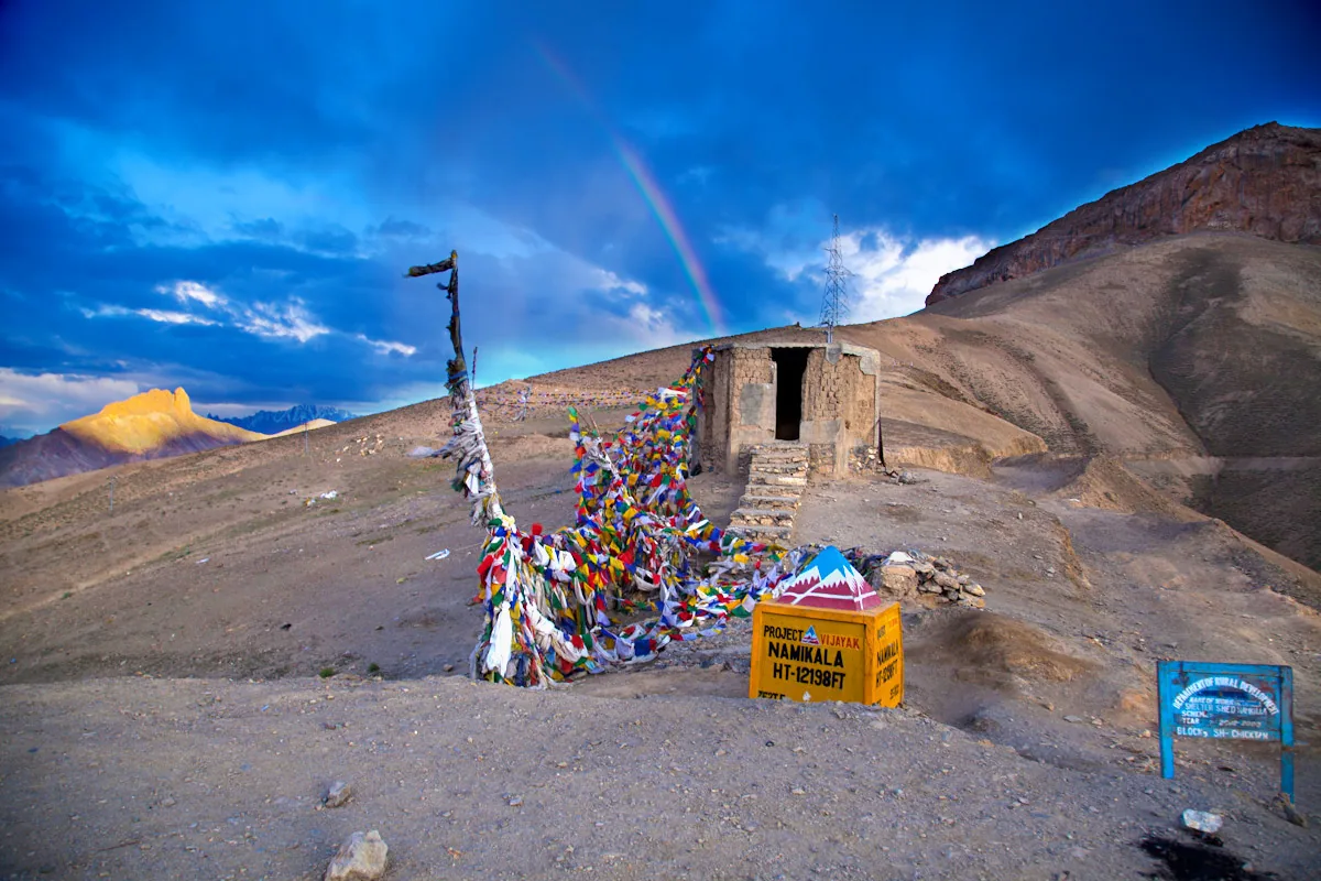
THE SUMMIT CHORTEN & PRAYER FLAG SEAS: At the summit crest, a pristine whitewashed Buddhist chorten (stupa) stands against the craggy sandstone skyline, enveloped by dense canopies of lungta prayer flags strung across wooden poles and crags. These flags - printed in the sacred five elements (blue for sky, white for air, red for fire, green for water, yellow for earth) - carry sacred mantras meant to bless every traveler who crosses the pass. Local Ladakhi and Zanskari drivers invariably stop to touch the stupa and chant 'Ki Ki So So Lha Gyalo' ('May the Gods be Victorious!') before continuing their journey.
THE DESCENT INTO MULBEKH'S 8TH-CENTURY SPLENDOR: As you complete the western descent from Namika La, the highway rolls into the historic town of Mulbekh. Here, towering beside the roadway, stands the famous Mulbekh Chamba - a colossal 30-foot-tall relief statue of Maitreya Buddha carved directly into a solitary limestone rock face during the 8th century Kushan-Tibetan era. Combining Namika La's high-altitude sweepers with an afternoon halt at the Chamba shrine makes for one of the most culturally profound day rides in Ladakh.
Senior Fleet Mechanic's Suspension Preload & Chassis Balance on NH1 High-Speed Sweepers
Answer-First Summary: Dialing in suspension damping, steering rake angles, and center-stand ground clearance on sweeping mountain bitumen.
At Ride & Fire Rentals, our workshop mechanics set up adventure touring motorcycles to handle the unique transition from the tight hairpins of Fotu La to the flowing, high-speed sweepers of Namika La. When you are carrying sustained 60 to 70 km/h speeds through banked asphalt curves, chassis balance and cornering clearance become paramount.
STEERING RAKE & FORK COMPRESSION: On modern adventure bikes like the Royal Enfield Himalayan 450, the front Showa upside-down forks feature 200 mm of plush travel. Under heavy trail-braking into Namika La's descending sweepers, the front end compresses significantly, steepening the steering head angle. If your front tire pressure is too low (below 20 PSI), the tire carcass flexes laterally, producing a vague, wandering sensation mid-corner. Maintain exactly 22 PSI front and 32 to 34 PSI rear to support the tire sidewalls and deliver laser-precise corner tracking.
CORNERING CLEARANCE & FOOTPEG PLACEMENT: The generous banking and smooth bitumen of Namika La encourage deeper lean angles than almost anywhere else in Ladakh. However, on fully laden motorcycles fitted with aftermarket crash guards, wide aluminum side panniers, or heavy center-stands, aggressive leaning can cause hard parts to scrape the road. PILOT TIP: Ride on the balls of your feet with your boot toes tucked tightly against the engine cases, rather than letting your boot heels hang off the footpegs where they can catch on the asphalt.
REBOUND DAMPING OVER FAST ROLLERS: The high-altitude plains of Bodhkharbu and Mulbekh feature occasional gentle asphalt undulations caused by permafrost heaving. If your rear shock rebound damping is set too fast, the rear end will pogo and bounce repeatedly after hitting a roller at 65 km/h, unsettling the motorcycle. Increase rear rebound damping by 2 clicks to settle the chassis quickly and maintain tire traction.
CHAIN CLEANING AFTER DESERT WINDSTORMS: The fine mineral dust swept across Namika La is notorious for drying out drive chain lubricants. After riding through the pass, inspect your chain rollers; if they appear shiny, silver, and dry, apply a coat of dry-film wax chain lubricant upon reaching your evening hotel in Kargil or Lamayuru to preserve your O-rings for the grueling passes ahead.
Permits, Safety Protocols & Emergency Medical Resources on NH1
Answer-First Summary: Zero-permit accessibility, military checkpoints, and local healthcare outposts between Leh and Kargil.
Navigating the administrative and safety aspects of riding across Namika La is straightforward and rider-friendly.
NO PERMIT MANDATE: Because National Highway 1 is a primary public defense highway, neither Indian domestic tourists nor international foreign travelers require an Inner Line Permit (ILP) or Protected Area Permit (PAP) to cross Namika La Pass. You can freely ride back and forth between Leh and Kargil with standard driver credentials.
CHECKPOINTS & DOCUMENTS: Indian riders should carry their original Driving License, Vehicle Registration Certificate (RC), and valid Pollution Under Control (PUC) certificate. Foreign nationals should keep their original passport and Indian visa handy for routine verification at the Pashkum Police Checkpost (15 km before Kargil).
EMERGENCY HEALTHCARE ACCESS: In the rare event of severe altitude sickness, acute dehydration, or mechanical breakdowns, primary healthcare outposts (PHC) with emergency oxygen cylinders operate at Bodhkharbu (10 km east) and Mulbekh (15 km west). Full-scale multi-specialty trauma centers operate at Kargil District Hospital (51 km west) and SNM Hospital in Leh (165 km east).
Route Milestones, Elevation & Road Conditions
| Milestone | Elevation (ft / m) | Distance from Kargil | Road Surface & Highway Telemetry |
|---|---|---|---|
| Kargil City Center | 8,780 ft / 2,676 m | 0 km | Major urban hub, multi-brand petrol pumps, hotels, mechanic workshops. |
| Pashkum Police Checkpoint | 9,100 ft / 2,774 m | 15 km | Routine document check, ancient fort ruins, smooth double-lane NH1. |
| Shargole Monastery Turnoff | 9,800 ft / 2,987 m | 30 km | Spur road to unique cave-cliff monastery; highway continues east. |
| Mulbekh Chamba Rock Carving | 10,800 ft / 3,292 m | 40 km | 30-ft 8th-century Maitreya Buddha relief, cafes, tyre puncture repair. |
| Wakha River Gorge Approach | 11,200 ft / 3,414 m | 46 km | Arid sandstone canyon, gradual 5% incline, sweeping BRO curves. |
| Namika La West Approach Ramp | 11,600 ft / 3,535 m | 50 km | Broad 3rd-gear sweepers, colorful mineral ridges, lateral crosswinds. |
| Namika La Pass Summit | 12,198 ft / 3,718 m | 55 km | Pillar of the Sky crest, Buddhist chorten, prayer flags, viewpoint. |
| Bodhkharbu Willow Oasis | 10,800 ft / 3,292 m | 65 km | Lush agricultural valley, homestays, BRO road maintenance camp. |
| Jalebi Bends Hairpin Series | 12,400 ft / 3,780 m | 77 km | 14 continuous stacked switchbacks leading toward Fotu La. |
| Fotu La Pass Summit | 13,478 ft / 4,108 m | 85 km | Highest motorable point on NH1, Prasar Bharati TV tower. |
| Lamayuru Monastery & Moonland | 11,520 ft / 3,510 m | 105 km | 11th-century Gompa, yellow clay geological formations, cafes. |
| Khaltse Bridge & Petrol Pump | 9,800 ft / 2,987 m | 125 km | IOCL petrol station, food stalls, confluence of Sham Valley. |
| Leh Main Market | 11,562 ft / 3,524 m | 216 km | Ride & Fire Rentals, full-service workshop, destination basecamp. |
Ready for Your Ladakh Motorcycle Adventure?
Navigating the complex checkpoints and steep elevations of UT Ladakh requires both legal compliance and mechanical reliability. At Ride & Fire Rentals, we offer locally registered motorcycles with the mandatory LA-02 yellow commercial plates, ensuring you clear every military and union checkpoint seamlessly. Our fleet is 100% fuel-injected and thoroughly checked before every handover at our Changspa Road workshop.
For external travel planning references, you can check the official Ladakh Tourism Portal or apply for permits via the LAHDC Leh Permit Portal.
Season Launch Offer
Book your motorcycle direct from our Changspa Road facility. Get a standard 25% direct booking discount, plus enter coupon code LADAKH5 at checkout for an extra 5% off (saving nearly 30% total) on your entire rental! This promotion is active until June 30.
Frequently Asked Questions
What is the elevation of Namika La Pass? +
Namika La Pass sits at an altitude of 12,198 feet (3,718 meters) above sea level. It is the second major mountain pass crossed on National Highway 1 between Leh and Kargil, positioned between Bodhkharbu and Mulbekh.
Do I need an Inner Line Permit (ILP) to visit Namika La Pass? +
No. Namika La Pass is located on National Highway 1, an open national highway corridor. Neither Indian domestic travelers nor foreign tourists require an Inner Line Permit (ILP) or Protected Area Permit (PAP) to ride across the pass.
What does 'Namika La' mean in the local language? +
In Ladakhi and classical Tibetan, 'Nam-ika La' translates directly to 'The Pillar of the Sky'. The pass was named after the distinctive vertical rock spires and sandstone geological towers that rise around the summit ridge like natural pillars supporting the heavens.
How are the road conditions across Namika La Pass? +
Road conditions across Namika La are outstanding. Engineered and maintained by the Border Roads Organisation (BRO) Project VIJAYAK, the entire pass features smooth, wide double-lane asphalt with broad, well-banked sweeping curves that are ideal for adventure motorcycles.
Where is the nearest petrol pump to Namika La Pass? +
There are no retail fuel bunks on Namika La. Heading west, the nearest petrol stations are in Kargil City, located 51 km away. Heading east, the nearest fuel station is the Indian Oil (IOCL) pump at Khaltse, located 69 km away. Always ensure you have a sufficient fuel reserve before leaving Khaltse or Kargil.
Is Namika La Pass open during winter? +
Namika La typically remains open for 10 to 11 months of the year, from late April or May through December or early January. Because it lies in an arid trans-Himalayan rain-shadow zone, snowfall is relatively light compared to Kashmir's Zoji La, though temporary closures occur during major winter blizzards.
Can I combine Namika La with Mulbekh and Lamayuru in a single day? +
Yes. A popular and highly scenic full-day ride from Leh spans 115 km to Lamayuru for morning exploration, continues 20 km across Fotu La Pass (13,478 ft), crosses Namika La Pass (12,198 ft) at km 165, and halts at Mulbekh (km 190) to view the 8th-century Chamba statue before returning or overnighting in Kargil.