
Quick Summary: What is the significance of Fotu La Pass on the Srinagar-Leh Highway?
Quick Answer: At an elevation of 13,478 feet (4,108 meters), Fotu La Pass is the highest motorable point on National Highway 1 (NH1) connecting Srinagar to Leh. Surpassing Zoji La (11,575 ft) by nearly 2,000 feet, Fotu La features impeccably engineered BRO double-lane asphalt, iconic switchback climbs from Lamayuru and Bodhkharbu, the prominent high-altitude Prasar Bharati television relay tower, and serves as the primary geographical divider between the Indus Valley and the Kargil basin.
The Apex of NH1: Why Fotu La Demands Every Rider's Respect
Answer-First Summary: Unraveling the geography, elevation dynamics, and tactical importance of the highest pass between Srinagar and Leh.
Among travelers planning their first trans-Himalayan motorcycle expedition, the treacherous reputation of Zoji La often overshadows every other high-altitude crossing on National Highway 1 (NH1). Yet, in terms of sheer altitude and atmospheric pressure drop, the true crown of the Srinagar-Leh highway belongs to Fotu La. Situated at 13,478 feet (4,108 meters) above sea level, Fotu La stands nearly 2,000 feet higher than Zoji La, making it the highest geographical crest crossed anywhere along the 420-kilometer arterial link between Kashmir and Ladakh.
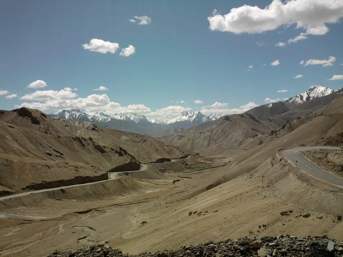
Carved across the rugged spine of the Zanskar mountain range, Fotu La separates the deep Indus River gorge of Sham Valley from the high arid interior plateaus of Kargil district. As riders ascend past the lunar clay pinnacles of Lamayuru, the highway transitions into an epic engineering showcase built and maintained by Border Roads Organisation (BRO) Project VIJAYAK. Double-lane bitumen curves drape gracefully across barren scree slopes, climbing in sweeping gradients toward a stark, wind-scoured summit.
At the summit crest, a vibrant forest of Buddhist prayer flags snaps violently in high-altitude crosswinds against the backdrop of the iconic Prasar Bharati television relay tower. Serving as the primary telecommunications and broadcast link for remote western Ladakh, this steel mast stands as a solitary sentinel over one of the most magnificent alpine road vistas on earth. For motorcyclists riding with Ride & Fire Rentals, crossing Fotu La marks the official entry into the high-altitude realm where proper engine tuning, throttle discipline, and biological acclimatization become essential to daily survival.
Elevation Physics & Barometric Transition: Sea Level to 13,478 Feet
Answer-First Summary: Understanding how a 40% reduction in atmospheric pressure impacts engine combustion and human physiology.
Crossing Fotu La introduces riders to significant barometric changes that test both machine mechanics and human physiology. At 13,478 feet, atmospheric pressure hovers around 62 kPa compared to 101.3 kPa at sea level. The air contains approximately 38% fewer oxygen molecules per breath. While modern fuel-injected motorcycles automatically adjust their air-fuel mixture, riders who have rushed their ascent from lower altitudes will immediately feel the physiological effects of hypoxemia.
THE BIOLOGICAL ACCLIMATIZATION DIVIDE: If you are riding west from Leh toward Kargil, you are already acclimatized to 11,562 feet after resting at least 48 hours in Leh as detailed in our Leh Acclimatization Guide. Ascending the additional 1,900 feet to Fotu La represents a minor, easily manageable physiological step. However, for riders ascending east from Srinagar or Kargil (8,780 ft), climbing directly to 13,478 feet represents a sharp 4,700-foot leap in elevation within a few hours. Acute Mountain Sickness (AMS) symptoms - including throbbing temple headaches, shortness of breath, and sudden fatigue - frequently strike riders who linger too long at the summit.
THE ENGINE COMBUSTION DEFICIT: Even on modern electronic fuel injection (EFI) engines like the Royal Enfield Himalayan 450's Sherpa 452 powertrain or the KTM 390 Adventure, atmospheric rarefaction reduces internal cylinder oxygen density. Every naturally aspirated engine loses roughly 3% of its peak brake horsepower for every 1,000 feet of elevation gain above sea level. By the time your wheels roll across the Fotu La summit marker, your engine is operating at roughly 60% of its sea-level power output. Overtaking heavy army supply trucks on uphill switchbacks requires deliberate planning, earlier downshifts, and full reliance on mid-range torque rather than top-end horsepower.
The Prasar Bharati TV Relay Station: High-Altitude Sentinel of NH1
Answer-First Summary: Engineering triumph, microwave communications, and the solitary landmark crowning the summit ridge.
Crowning the barren ridgeline directly adjacent to the highway summit sits the Prasar Bharati Fotu La Television and Radio Relay Station. Standing at an extreme elevation of over 13,500 feet, this broadcast installation is one of the highest television relay transmitters on the planet.
HISTORICAL & STRATEGIC IMPORTANCE: Erected by the Government of India during the late 20th century, the relay tower was engineered to beam terrestrial television and All India Radio signals deep into the isolated valleys of Kargil, Drass, and Sham. In a region where deep mountain ranges block standard radio frequency propagation, the line-of-sight elevation of Fotu La provides an unobstructed microwave relay corridor connecting the central transmission facilities in Leh with border communication posts along the Line of Control (LoC).
SUMMIT LANDMARKS & PHOTOGRAPHY: While the interior compound of the relay station is an Indian military and communications zone closed to civilians, the roadside public viewpoint adjacent to the tower offers phenomenal photographic perspectives. Standing beside the prayer-flag-draped stupa, riders can look east to trace the white ribbon of NH1 coiling down into the Lamayuru Moonland, or gaze west across the jagged sawtooth crests of the Zanskar range fading into the horizon toward Kargil.
Mechanical Telemetry: Carburetor Jetting, EFI Pressure & Cooling Systems
Answer-First Summary: Senior Mechanic Stanzin Dorje explains fuel rail pressures, throttle hesitation, and spark plug readouts.
At Ride & Fire Rentals, we prepare our rental fleet for the rigors of high-altitude pass crossings daily. Understanding how Fotu La stresses critical motorcycle subsystems ensures an uninterrupted journey across the roof of Ladakh.
ELECTRONIC FUEL INJECTION (EFI) ADAPTATION: Modern EFI machines utilize a Manifold Absolute Pressure (MAP) sensor and an ambient barometric pressure sensor to calculate intake air mass. As you ascend toward 13,478 feet, the engine control unit (ECU) shortens injector pulse widths, trimming fuel delivery to maintain a stoichiometric 14.7:1 air-fuel ratio. On machines like the Royal Enfield Himalayan 450, this self-calibration occurs continuously. However, if your machine hesitates or stutters during rapid throttle roll-ons near the summit, pull over for 60 seconds, turn the ignition off, and restart the motorcycle without touching the throttle. This forces the ECU to re-sample baseline ambient pressure, clearing fuel trim lag.
CARBURETOR JETTING WARNING: If you are riding an older carbureted motorcycle (such as a classic Royal Enfield Bullet 350/500 or Himalayan 411 Carb), the engine will run excessively rich as ambient air thins. Symptoms include black sooty exhaust smoke, bogging down under load, and fouled spark plugs. Experienced mechanics drop the carburetor needle clip by one notch or reduce the main jet size by 5 to 10% in Leh before attempting the Fotu La and Namika La pass climbs.
RADIATOR FAN CYCLES & HIGHWAY HEAT: Despite chilly ambient summit temperatures (typically 6°C to 14°C in summer), sustained climbing in 2nd and 3rd gear generates immense internal engine heat. Thinner air reduces heat transfer across aluminum radiator cores by approximately 25%. Expect your cooling fan to run continuously during the final 5 kilometers of the climb. Never shut down a hot engine immediately upon reaching the summit; allow the motor to idle for 45 seconds so coolant circulation can dissipate cylinder head heat soak.
Wind Dynamics & Thermal Updrafts: Aero-Stability on High Ridge Crossings
Answer-First Summary: Managing crosswind shears, luggage drag, and rider fatigue on the exposed Fotu La summit ridge.
One of the defining challenges of Fotu La is the ferocious wind regime that scours the pass from late morning through sunset. The dramatic temperature differential between the warm Indus Valley floor and the freezing alpine crags generates powerful thermal updrafts that funnel through the pass.
SUMMIT CROSSWIND PHYSICS: As you break out of the sheltered canyon hairpins of Lamayuru onto the open ridge above 12,500 feet, sudden lateral wind gusts of 50 to 70 km/h will strike your motorcycle broadside. If you are carrying large aluminum side panniers or a high-mounted duffel bag on the rear luggage rack, these bags act as aerodynamic sails, generating lateral yaw moments that push your front wheel across the road line.
STABILIZATION TECHNIQUE: When encountering heavy crosswinds, relax your upper body. Squeezing the handlebar grips with white knuckles transfers every wind gust directly into your steering head, inducing high-speed chassis weave. Instead, clamp the fuel tank firmly with your thighs, bend your elbows to absorb buffeting, and maintain a steady cruising speed of 45 to 55 km/h. Lean slightly into the prevailing wind while applying gentle counter-steering pressure to hold a laser-straight line across the ridge.
SUNSET WIND PLUMMET: As radiant solar heating ceases in late afternoon, summit winds shift direction and ambient temperatures plummet dramatically. A mild 16°C afternoon can turn into a bone-chilling 2°C within 45 minutes of sunset. Always layer your windproof riding jacket with an insulated thermal liner before leaving Lamayuru or Bodhkharbu.
Fuel Logistics & Range Math: The 135 km Dead Zone from Khaltse to Kargil
Answer-First Summary: Calculating tank ranges, commercial pump locations, and fuel reserve requirements across the two passes.
Fuel planning for the Fotu La crossing requires disciplined mathematics, as the pass sits directly in the middle of a major commercial fueling void on NH1.
FUEL DEAD ZONE MATHEMATICS: The last reliable fuel station when leaving Leh heading west is the Indian Oil (IOCL) pump at Khaltse (km 96 from Leh). Heading west across Fotu La and Namika La, there are NO commercial petrol pumps until you reach Kargil City (km 216 from Leh). This represents a continuous 120-kilometer fuel gap across two major mountain passes (Fotu La at 13,478 ft and Namika La at 12,198 ft).
CONSUMPTION IMPACT OF HIGH-ALTITUDE CLIMBS: While a 400cc single-cylinder machine normally returns 30 to 32 km/L on flat highway asphalt, sustained climbing in lower gears across two mountain summits increases fuel consumption by 25 to 30%, reducing average economy to 22 to 24 km/L. A 120 km mountainous stretch requires a minimum of 5.5 to 6.5 liters of usable petrol.
PUMP RECOMMENDATION: Never pass Khaltse with less than 60% fuel in your main tank. Pull into the Khaltse IOCL station, top your tank to 100% capacity, and verify that your fuel filler cap seals tightly. If you are continuing directly from Kargil into the remote Suru Valley or toward Padum in Zanskar as detailed in our Kargil City Transit Guide, top up again at the HPCL or IOCL bunks upon entering Kargil.
Senior Fleet Mechanic's Pre-Pass Shakedown Checklist: Brakes, Chain & Tires
Answer-First Summary: Stanzin Dorje's mandatory 5-point inspection before attacking the highest pass on National Highway 1.
Before rolling your machine out of Lamayuru or Khaltse to tackle Fotu La, take 5 minutes to perform our Ride & Fire pass safety inspection.
1. BRAKE FLUID WATER CONTAMINATION CHECK: Continuous downhill braking on the 1,900-foot descent from Fotu La generates tremendous caliper heat. If your brake fluid contains absorbed moisture, it will boil at high altitude, producing complete vapor lock and sudden lever fade. Inspect your brake fluid sight glass; fluid must appear clear amber or translucent yellow. If it looks dark brown or cloudy, flush the system before crossing the pass.
2. DRIVE CHAIN SLACK IN HARSH COLD: Cold ambient temperatures cause drive chains to contract slightly. Verify that your chain slack sits between 25 and 30 mm while resting on the side stand. Apply a high-adhesion dry wax chain lube to prevent abrasive granite grit from wearing out your sprocket teeth.
3. COLD TIRE PRESSURE READINGS: High-altitude solar radiation heats up tire carcasses during the fast climb. Set cold morning pressures to 22 PSI front and 32 PSI rear (solo) or 34 PSI rear (with luggage). This ensures maximum rubber contact patch across the smooth banked bitumen without overheating the internal casing.
4. REAR SHOCK PRELOAD SETTING: The sweeping high-speed bends of Fotu La reward a balanced chassis. Increase your rear shock preload by 1 to 2 notches if carrying hard luggage to preserve forward weight bias and prevent front-end vagueness in mid-corner bumps.
5. OPTICAL VISOR MAINTENANCE: Clean your helmet visor with fresh water and a microfiber cloth. Midday sunlight at 13,478 feet carries extreme ultraviolet intensity; ride with a dark smoke visor or internal polarized sunshield to prevent blinding retinal glare off the light-colored limestone cliffs.
Permit Regulations, Military Checkpoints & Transit Logistics
Answer-First Summary: Inner Line Permit rules, document checks at Khaltse and Kargil, and emergency medical resources.
Travelers frequently ask whether special permits are required to cross Fotu La. Because National Highway 1 is a primary strategic civilian and defense transportation corridor, permit regulations are straightforward.
INNER LINE PERMIT EXEMPTION: Neither Indian domestic citizens nor foreign passport holders require an Inner Line Permit (ILP) or Protected Area Permit (PAP) to ride across Fotu La Pass or travel anywhere along the open Srinagar-Leh NH1 corridor. You may ride freely between Leh, Lamayuru, Fotu La, Namika La, Mulbekh, and Kargil.
POLICE & ARMY CHECKPOINTS: You will encounter two routine administrative checkpoints on this corridor: the Khaltse Police Checkpost (km 96 from Leh) and the Pashkum Checkpoint (km 201, 15 km before Kargil). Indian riders should present their driving license and vehicle registration. Foreign travelers must present their original passport and valid Indian visa. Registration takes under two minutes.
EMERGENCY MEDICAL CARE: In case of acute altitude distress or road emergencies, the nearest military medical room is located at the BRO Camp in Bodhkharbu (20 km west). The Khaltse Sub-District Hospital (39 km east) and the Kargil District Hospital (81 km west) provide 24/7 emergency medical trauma care, high-capacity oxygen concentrators, and ambulance services.
Route Milestones, Elevation & Road Conditions
| Milestone | Elevation (ft / m) | Distance from Leh | Road Condition & Highway Telemetry |
|---|---|---|---|
| Leh Main Market | 11,562 ft / 3,524 m | 0 km | Ride & Fire Rentals, full workshops, IOCL fuel pumps, ATMs. |
| Nimmu (Sangam Confluence) | 10,400 ft / 3,170 m | 33 km | Pristine double-lane NH1, riverside cafes, Zanskar junction. |
| Khaltse Bridge & Police Post | 9,800 ft / 2,987 m | 96 km | Last commercial IOCL petrol pump before Kargil, document check. |
| Lamayuru Moonland Viewpoint | 11,400 ft / 3,475 m | 113 km | Yellow clay formations, roadside parking, homestays. |
| Lamayuru Monastery Gate | 11,520 ft / 3,510 m | 115 km | 11th-century Gompa, cafes, mechanic shacks, tyre puncture repair. |
| Wanla Valley Junction | 11,200 ft / 3,414 m | 122 km | Left turn for Wanla-Zanskar route; stay right on NH1 for Fotu La. |
| Jalebi Bends Hairpin Series | 12,400 ft / 3,780 m | 128 km | 14 continuous stacked paved switchbacks, smooth banked bitumen. |
| Fotu La Pass Summit | 13,478 ft / 4,108 m | 135 km | Highest motorable point on NH1, prayer flags, stupa, wind gusts. |
| Prasar Bharati TV Relay Station | 13,500 ft / 4,115 m | 135.2 km | High-altitude broadcast tower, strategic microwave relay. |
| Bodhkharbu Willow Oasis | 10,800 ft / 3,292 m | 155 km | Broad green agricultural valley, homestays, BRO road maintenance camp. |
| Namika La Pass Summit | 12,198 ft / 3,718 m | 165 km | Pillar of the Sky pass, Buddhist stupa, sweeping tarmac. |
| Mulbekh Chamba Rock Relief | 10,800 ft / 3,292 m | 190 km | 30-ft 8th-century Maitreya Buddha rock carving, monastery. |
| Kargil City Center | 8,780 ft / 2,676 m | 216 km | Major urban transit hub, hotels, multiple fuel bunks, mechanics. |
Ready for Your Ladakh Motorcycle Adventure?
Navigating the complex checkpoints and steep elevations of UT Ladakh requires both legal compliance and mechanical reliability. At Ride & Fire Rentals, we offer locally registered motorcycles with the mandatory LA-02 yellow commercial plates, ensuring you clear every military and union checkpoint seamlessly. Our fleet is 100% fuel-injected and thoroughly checked before every handover at our Changspa Road workshop.
For external travel planning references, you can check the official Ladakh Tourism Portal or apply for permits via the LAHDC Leh Permit Portal.
Season Launch Offer
Book your motorcycle direct from our Changspa Road facility. Get a standard 25% direct booking discount, plus enter coupon code LADAKH5 at checkout for an extra 5% off (saving nearly 30% total) on your entire rental! This promotion is active until June 30.
Frequently Asked Questions
What is the elevation of Fotu La Pass? +
Fotu La Pass sits at an elevation of 13,478 feet (4,108 meters) above sea level. It is the highest motorable mountain pass on the entire 420-kilometer Srinagar-Leh National Highway (NH1), standing higher than both Zoji La (11,575 ft) and Namika La (12,198 ft).
Do I need an Inner Line Permit (ILP) to visit Fotu La Pass? +
No. Fotu La Pass is located directly on National Highway 1, which is a designated open national transportation corridor. Neither Indian domestic travelers nor foreign tourists require an Inner Line Permit (ILP) or Protected Area Permit (PAP) to cross the pass or ride between Leh and Kargil.
How are the road conditions across Fotu La Pass? +
Road conditions across Fotu La are exceptional. The entire pass is maintained by the Border Roads Organisation (BRO) under Project VIJAYAK and features smooth, double-lane high-friction asphalt with well-banked switchbacks (the famous Jalebi Bends) on both the eastern and western approaches.
Where is the nearest petrol pump to Fotu La Pass? +
The nearest fuel station east of Fotu La is the Indian Oil (IOCL) pump in Khaltse, located 39 km away (km 96 from Leh). The nearest fuel station west of the pass is in Kargil City, located 81 km away. Make sure to fill your tank at Khaltse when riding west toward Kargil.
Is Fotu La Pass open throughout the year? +
Fotu La Pass generally remains open for most of the year, from late April or May through December or early January. Unlike Zoji La, which receives massive snowdrifts, Fotu La lies in an arid rain-shadow zone and experiences less snowfall. However, temporary closures of 12 to 48 hours occur during heavy winter blizzards.
How does Fotu La compare to Zoji La for motorcyclists? +
While Fotu La is nearly 2,000 feet higher than Zoji La (13,478 ft vs 11,575 ft), it is vastly easier and safer to ride. Fotu La is fully paved with wide double-lane asphalt, sturdy crash barriers, and engineered switchbacks, whereas Zoji La features unpaved mud ruts, heavy truck congestion, and sheer cliff drops without guardrails.
Can I cross Fotu La Pass on a rental motorcycle from Leh? +
Yes. You can ride any commercial LA-02 yellow-plate motorcycle rented from Ride & Fire Rentals in Leh across Fotu La Pass to Kargil and onwards to Srinagar. Under Ladakh Motor Bike Rental Association (LMBRA) rules, Leh-registered rental bikes have complete operational clearance along the entire NH1 corridor.