
Quick Summary: Where is the Mulbekh Chamba rock carving located and what is its historical significance?
Quick Answer: Mulbekh Chamba (10,800 ft / 3,292 m) is located 40 km east of Kargil and 190 km west of Leh along the paved Srinagar-Leh National Highway 1 (NH1). It features a monumental 30-foot (9-meter) high-relief rock carving of Maitreya Buddha (Chamba) chiseled into a massive limestone crag dating back to the 7th-8th century CE. It marks the cultural crossroads where the Shia Muslim culture of Kargil transitions into the Buddhist valleys of Ladakh. Visiting is free, roadside parking is available, and it is an essential 30-minute cultural rest stop before crossing Namika La (12,198 ft).
The Monumental Masterpiece: 30-Foot High-Relief Maitreya Buddha & Silk Route Origins
Answer-First Summary: Chiseled into a vertical limestone crag over 1,200 years ago, this 9-meter carving blends Gandharan, Kashmiri, and early Buddhist iconography.
Cruising east from Kargil along the sweeping asphalt curves of National Highway 1, the barren granite canyon of the Wakha River suddenly expands into a broad green agricultural valley. Rising dramatically beside the northern edge of the highway is an immense, tooth-shaped limestone monolith towering above the whitewashed houses of Mulbekh village (elevation 10,800 ft / 3,292 m). Chiseled with astonishing artistic precision directly into the south-facing rock face is one of the greatest archaeological treasures of Central Asia: the colossal Mulbekh Chamba.
The sculpture depicts Maitreya Buddha - the Future Buddha (known locally in Ladakhi as Chamba or Gyalwa Jampa) - standing in a dignified, serene erect posture (samabhanga). Towering over 30 feet (9 meters) in height, this high-relief carving is a masterwork of trans-Himalayan rock art. Art historians and archaeologists date the carving to the 7th or 8th century CE, during the golden era when Buddhism flourished along the trans-Himalayan silk and trade caravans connecting Kashmir, Gilgit, Ladakh, and Western Tibet.
What captivates scholars and art historians is the sculpture's distinctive Kashmiri-Gandharan stylistic execution, which predates the later Tibetan monastic orthodoxy that dominated Ladakh from the 11th century onward. The figure wears the sacred Brahmanical cord (Yajnopavita) draped diagonally across his muscular torso, a delicate antelope skin (krishnajina) slung over his left shoulder, and elaborate beaded armlets. In his left hand, he holds the ritual water vessel (Kamandalu), while his right hand is raised in the protective gesture of teaching.
Around the base of the rock face, weathered ancient inscriptions carved in Kharosthi and early Brahmi script record the names of silk route merchants and royal patrons who funded the carving to seek spiritual protection against bandits, rock avalanches, and treacherous blizzards while crossing the high passes of Namika La and Fotu La.
Silk Route Inscriptions & Epigraphic Secrets: Kharosthi, Brahmi & Tibetan Carvings
Answer-First Summary: Ancient caravan merchants etched votive prayers and royal edicts into the living limestone surrounding the statue.
Beyond the aesthetic grandeur of the Maitreya figure, the limestone monolith at Mulbekh is an irreplaceable open-air epigraphic library. For centuries before formal highway engineering, this exact cliff base served as the mandatory resting station for merchant caravans transiting between Srinagar, Skardu, Leh, and Yarkand.
Caravan leaders and pilgrim monks etched votive graffiti, donor names, and protective mantras into the rock surfaces surrounding the statue. Epigraphists have identified inscriptions in three distinct historical scripts: early Kharosthi script dating back to the Kushan era, classical Gupta-period Brahmi script, and archaic Tibetan dbu-can script.
THE EDICT OF KING LHACHEN GYALPO: Among the most significant historical records is an ancient Tibetan royal inscription attributed to King Lhachen Gyalpo (c. 14th century). The royal decree explicitly commands the local population to cease the ancient pagan practice of animal sacrifice to local mountain spirits (lhas and shindjes), declaring that blood offerings violated Buddhist dharma. This stone inscription provides priceless archaeological evidence of the historical transition from pre-Buddhist shamanic animism to codified Tibetan Buddhism in western Ladakh.
CONSERVATION BY THE ASI: The Archaeological Survey of India (ASI) has designated the Mulbekh Chamba as a protected monument of national importance. To protect the soft limestone carving from accelerated weathering caused by vehicle exhaust fumes along NH1 and winter ice wedging, specialized silicon-based water repellents and structural micro-grouting have been applied, ensuring this 1,200-year-old masterpiece survives for future generations of travelers.
The Wakha River Valley Agricultural Ecosystem: Ancient Irrigation Channels & Traditional Homestays
Answer-First Summary: The lush oasis of Wakha: glacial canal networks (chhur), barley farming, and traditional Purig homestays.
Stepping away from the highway shoulder reveals the lush agrarian oasis of the Wakha River valley. While surrounding mountains are completely arid and devoid of natural vegetation, the village floor of Mulbekh is an intricate tapestry of terraced green fields, weeping willow groves, and ancient poplar windbreaks.
TRADITIONAL GLACIAL CANAL IRRIGATION: The entire farming ecosystem relies on ancient gravity-fed irrigation channels known as *chhur*. Local water masters (*chhurpons*) divert crystal-clear glacial meltwater from the 18,000-foot ridges of the Zanskar range into intricate stone aqueducts that snake across the cliffs for miles. This water irrigates terraced fields of six-row barley (*nas*), bitter buckwheat (*gyas*), and sweet Ladakhi peas.
VILLAGE HOMESTAYS & PURIG CUISINE: Mulbekh offers several authentic family homestays where motorcycle travelers can experience genuine Purig hospitality. Guest rooms feature thick wool rugs, hand-carved low dining tables (*choktse*), and windows looking directly onto the limestone monastery crag. Staying overnight allows you to savor authentic regional cuisine rarely found in commercial restaurants: warm *kulcha* flatbreads baked in earthen tandoors, bowls of *skyu* (hand-rolled vegetable and pasta stew cooked over wood heat), and sweet dried apricots harvested from family orchards.
VILLAGE STROLL ETIQUETTE: Taking an evening walking stroll through the narrow earthen lanes between Mulbekh's mud-brick farmhouses is a peaceful contrast to hours of highway throttle vibration. Greet passing village elders with a polite 'Julley' or 'Salaam Alaykum', and always walk clockwise around village prayer wheels and mani stone cairns.
The Cultural Watershed: Where Suru Muslim Heritage Meets Buddhist Ladakh
Answer-First Summary: Mulbekh represents the precise geographic boundary where Islamic Kargil transitions into Buddhist Ladakh.
For motorcyclists traversing the 434 km Srinagar-Leh highway, Mulbekh is far more than an ancient sculpture; it marks a profound, fascinating cultural watershed. Driving east from Srinagar through the Kashmir Valley and Kargil, travelers journey through predominantly Muslim communities - the Sunni culture of Ganderbal, the Dardi-Shina culture of Drass, and the devout Shia Muslim communities of the Suru and Purig valleys surrounding Kargil, characterized by green-domed mosques and ornate mourning imambaras.
The moment you reach Mulbekh, the cultural atmosphere shifts palpably. Suddenly, colorful five-colored Buddhist prayer flags (lungta) flutter from flat mud-brick rooftops, whitewashed chortens (stupas) line the roadside, and massive mani stone walls carved with the sacred mantra 'Om Mani Padme Hum' run parallel to the highway blacktop.
Mulbekh has existed as a peaceful cultural melting pot for centuries. Families of Buddhist and Shia Muslim heritage have coexisted here for generations, sharing agricultural irrigation waters, intermarrying, and attending each other's festive celebrations. The village is an inspiring testament to Ladakh's historic tradition of communal harmony and trans-cultural tolerance.
The Twin Monasteries: Serdung Gompa & The Gelugpa Shrine on the Limestone Crag
Answer-First Summary: Exploring the ancient Drukpa Kagyu and Gelugpa temples perched at the base and pinnacles of the sacred rock.
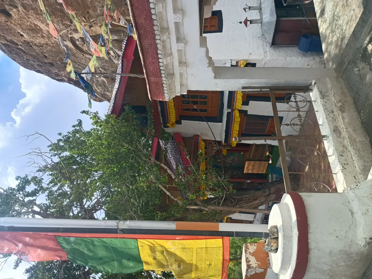
Surrounding and crowning the colossal rock carving are two distinct monastic sanctuaries representing different lineages of Tibetan Buddhism. At the immediate foot of the Maitreya carving stands Serdung Gompa, affiliated with the Drukpa Kagyu lineage. A modest whitewashed entrance leads into an intimate prayer chapel constructed right against the living rock, allowing visitors to stand just inches away from the feet of the ancient carving.
Inside the chapel, the air is thick with the soothing scent of burning juniper incense and clarified butter lamps. A resident monk sits quietly at a low wooden table, offering blessed saffron threads and white silk katas to travelers. Climb the short flight of internal wooden steps to an elevated gallery, which brings you to eye level with the intricate jewelry, waistband ribbons, and flowing drapes of the 8th-century Buddha.
For riders with energetic legs and sturdy riding boots, a steep, zigzagging stone footpath scales the eastern flank of the limestone pinnacle to reach the upper Gelugpa monastery perched precariously on the razor-sharp crag summit. The climb takes 15 to 20 minutes of sustained effort, but the panoramic reward from the monastery roof is spectacular - commanding an unobstructed view of the Wakha valley, the sweeping switchbacks of NH1, and the snowbound peaks of the Zanskar range to the south.
Motorcycle Highway Route: Riding from Kargil Across Namika La & Fotu La
Answer-First Summary: 40 km of smooth military blacktop from Kargil and preparing for the twin passes leading to Lamayuru.
The motorcycle ride between Kargil and Mulbekh is one of the most relaxing and scenic sections of National Highway 1. Leaving Kargil city center (elevation 8,780 ft), the highway follows the winding Suru River before veering east into the Wakha River valley.
The 40 km stretch to Mulbekh is impeccably paved military asphalt maintained by BRO Project VIJAYAK, with a gentle, sustained uphill gradient from 8,780 ft to 10,800 ftleaving Kargil City Center. Cruising speeds of 60 to 75 km/h are easily maintained across wide, sweeping corners with clear sightlines and minimal civilian traffic.
CONTINUING EAST OVER THE TWIN PASSES: Mulbekh is the mandatory staging point before tackling the twin high passes of the Srinagar-Leh highway. Immediately after leaving Mulbekh village, NH1 begins a 12 km winding climb up to Namika La Pass (elevation 12,198 ft / 3,718 m, meaning "Pillar of the Sky"). The ascent features wide, beautifully banked asphalt hairpins with zero gravel hazards.
Descending from Namika La takes you through the fertile oasis of Bodh Kharbu (km 65 from Kargil), before the highway begins its final major climb to summit Fotu La Pass (13,478 ft / 4,108 m) - the highest elevation on the entire highway between Srinagar and Leh. Crossing Fotu La leads directly down into the breathtaking switchbacks of Lamayuru and Moonland.
Fuel Planning, Mechanical Checks & Roadside Rest Facilities at Mulbekh Village
Answer-First Summary: Managing fuel ranges between Kargil and Khaltse, carburetor/EFI power tuning, and roadside dhaba stops.
Senior Fleet Mechanic Stanzin Dorje offers the following operational advice for riders passing through Mulbekh:
FUEL LOGISTICS WARNING: There are NO commercial retail petrol pumps in Mulbekh village. The last official fuel stations heading east are the Indian Oil and HPCL pumps in Kargil (40 km west). The next official fuel pump heading east toward Leh is at Khaltse - located 100 km away over two major mountain passes (Namika La and Fotu La). Always top up your motorcycle tank to 100% capacity in Kargil before embarking on this stretch.
ENGINE PERFORMANCE OVER NAMIKA LA: As you climb from Kargil (8,780 ft) past Mulbekh (10,800 ft) to Namika La (12,198 ft) and Fotu La (13,479 ft), the ambient atmospheric oxygen drops by nearly 35%. On modern fuel-injected bikes (like the Royal Enfield Himalayan 450 or Scram 411), the ECU automatically recalibrates the air-fuel mixture, though you will notice a mild 10% to 15% reduction in top-end roll-on acceleration. Shift down one gear earlier when climbing passing trucks on ascending switchbacks.
ROADSIDE FACILITIES & FOOD: Directly opposite the rock carving along the highway shoulder, several clean Ladakhi and Kashmiri-run dhabas offer safe parking, clean restrooms, and hot meals. A piping hot cup of saffron-infused Kashmiri Kahwa with crushed almonds, or a warm bowl of vegetable noodle thukpa, provides the perfect physical boost before ascending the cold pass sectors.
Photography Lighting Angles, Drone Regulations & Local Monastery Etiquette
Answer-First Summary: Optimal photography times for the south-facing relief, drone prohibitions, and temple donations.
To capture the full grandeur of the Mulbekh Chamba, timing and lighting angles are essential considerations for traveling photographers.
LIGHTING & PHOTOGRAPHY WINDOW: Because the 30-foot Maitreya carving is chiseled into a south-facing limestone wall, the optimal lighting window occurs between 10:00 AM and 02:00 PM. During midday hours, direct sunlight illuminates the intricate high-relief details of the jewelry, waist sash, and serene facial expression without casting harsh horizontal shadows from the overhanging rock ledge.
DRONE REGULATIONS: The operation of civilian camera drones is strictly prohibited across the Mulbekh sector without written clearance from the Kargil District Magistrate and local military authorities. National Highway 1 is a sensitive strategic corridor, and unauthorized drone flights will result in immediate equipment confiscation and police detention.
TEMPLE CONTRIBUTIONS & ENTRY: Visiting the exterior Maitreya carving is 100% free of charge. Entering the interior Serdung Gompa prayer chapel does not require a formal entry ticket, but a voluntary donation of ₹20 to ₹50 into the monastery collection box is customary and deeply appreciated by the resident monks who maintain the ancient sanctuary.
Iconographic Comparison: Mulbekh Chamba vs Kartse Khar & Drass Maitreya Reliefs
Answer-First Summary: Analyzing Ladakh's trio of colossal rock-cut Maitreyas: stylistic evolution, Silk Route chronology, and preservation.
The Mulbekh Chamba is not an isolated artistic oddity; it is the crowning masterpiece of a triad of colossal rock-cut Maitreya Buddha sculptures carved across the Kargil and Suru regions during the early medieval era.
The second notable carving is the 20-foot standing Maitreya at Kartse Khar (near Sankoo in the Suru Valley, 45 km south of Kargil). While the Kartse Khar carving shares the distinctive Kashmiri styling, samabhanga posture, and sacred thread, it features a more slender, elongated torso and softer facial modeling. The third, a smaller Maitreya relief near Drass, exhibits early Gandharan monastic drapery.
Art historians suggest that these three monumental rock carvings formed a sacred pilgrimage and navigation corridor for Buddhist monks and merchants traveling from the Kashmir Valley and Swat across the high trans-Himalayan passes into Ladakh and Tibet. The monumental scale of the carvings served as beacons of spiritual protection and territorial markers of Buddhist royal patronage.
Among the three, Mulbekh remains the best preserved and most easily accessible, standing right beside the National Highway tarmac. Its deep relief carving, crisp anatomical detailing, and dramatic limestone crag setting make it an unmatched archaeological spectacle in the Himalayas.
BRAKE ROTOR THERMAL MANAGEMENT OVER NAMIKA LA: Climbing and descending the sweeping hairpins between Mulbekh (10,800 ft) and Namika La (12,198 ft) demands smooth throttle transitions and minimal brake abuse. The descent into Bodh Kharbu features several high-speed straightaways terminating in sharp 90-degree decreasing-radius turns. Avoid stabbing the front brake lever aggressively while leaned over; scrub your speed in a straight line before turn-in, and use progressive throttle roll-on through the apex to keep the motorcycle chassis stabilized on the cambered military blacktop.
Route Milestones, Elevation & Road Conditions
| Milestone | Elevation (ft / m) | Distance from Kargil | Key Facilities & Highway Telemetry |
|---|---|---|---|
| Kargil City Center | 8,780 ft / 2,676 m | 0 km | Major city, IOCL & HPCL fuel stations, hotels, ATMs, mechanics. |
| Wakha Checkpoint | 9,800 ft / 2,987 m | 25 km | Gentle highway climb, police checkpost, scenic river canyon. |
| Mulbekh Village | 10,800 ft / 3,292 m | 40 km | 30-ft Maitreya rock carving, twin monasteries, dhabas, tea stalls. |
| Namika La Pass Summit | 12,198 ft / 3,718 m | 52 km | High-altitude pass, prayer flags, broad asphalt hairpins. |
| Bodh Kharbu Village | 11,000 ft / 3,353 m | 68 km | Fertile oasis village, roadside tea shops, apricot orchards. |
| Heniskot Fortress Ruins | 11,400 ft / 3,474 m | 82 km | Ancient ruined hilltop fort, scenic mountain valley view. |
| Fotu La Pass Summit | 13,479 ft / 4,108 m | 100 km | Highest point on NH1 Srinagar-Leh, TV tower, panoramic views. |
| Lamayuru Village & Gompa | 11,520 ft / 3,510 m | 115 km | Ancient monastery, Moonland terrain, homestays, restaurants. |
| Khaltse Market & Fuel | 9,800 ft / 2,987 m | 140 km | Major town, 2 IOCL fuel pumps, police post, apricot markets. |
| Nimmu (Sangam) | 10,300 ft / 3,139 m | 195 km | Indus-Zanskar confluence, river rafting camps, smooth highway. |
| Leh Main Market | 11,562 ft / 3,524 m | 230 km | Capital of Ladakh, Ride & Fire Rentals, airport, hospitals. |
Ready for Your Ladakh Motorcycle Adventure?
Navigating the complex checkpoints and steep elevations of UT Ladakh requires both legal compliance and mechanical reliability. At Ride & Fire Rentals, we offer locally registered motorcycles with the mandatory LA-02 yellow commercial plates, ensuring you clear every military and union checkpoint seamlessly. Our fleet is 100% fuel-injected and thoroughly checked before every handover at our Changspa Road workshop.
For external travel planning references, you can check the official Ladakh Tourism Portal or apply for permits via the LAHDC Leh Permit Portal.
Season Launch Offer
Book your motorcycle direct from our Changspa Road facility. Get a standard 25% direct booking discount, plus enter coupon code LADAKH5 at checkout for an extra 5% off (saving nearly 30% total) on your entire rental! This promotion is active until June 30.
Frequently Asked Questions
How old is the Mulbekh Chamba rock carving in Ladakh? +
Historical and archaeological records indicate that the Mulbekh Chamba was carved during the 7th or 8th century CE (over 1,200 years ago) during the period of Kashmiri-Buddhist cultural expansion along the Silk Route. Some local oral traditions attribute its origins even earlier to the Kushan era of the 1st-2nd century CE.
Do you need to pay an entry fee to see Mulbekh Chamba? +
No. Viewing the 30-foot rock carving from the roadside is completely free of charge. Entering the small inner prayer chapel (Serdung Gompa) at the base of the rock is also free, though voluntary donations of ₹20 to ₹50 to support the resident monks are welcomed.
Do you need an Inner Line Permit (ILP) to visit Mulbekh? +
No. Mulbekh is situated directly on National Highway 1 (the Srinagar-Leh Highway), which is an open national transit highway. Neither Indian domestic travelers nor foreign tourists require an Inner Line Permit (ILP) or Protected Area Permit (PAP) to visit Mulbekh.
Where is the nearest petrol pump to Mulbekh? +
There are no fuel pumps in Mulbekh village. The nearest petrol stations heading west are in Kargil city (40 km away), while the nearest petrol station heading east toward Leh is at Khaltse (100 km away across Namika La and Fotu La passes). Riders should always fuel up in Kargil.
Can I ride an outside (non-local) rental motorcycle to Mulbekh? +
Yes. Because Mulbekh is located directly on National Highway 1, commercial rental motorcycles licensed outside Ladakh (such as DL, HR, or HP plates) are legally permitted to ride along NH1 between Srinagar, Kargil, and Leh.
What are the road conditions between Kargil and Mulbekh? +
The road condition between Kargil and Mulbekh is exceptional. It consists of wide, well-maintained two-lane military asphalt maintained by BRO Project VIJAYAK, with gentle curves, clear signboards, and minimal potholes.
How long does it take to explore Mulbekh Chamba? +
Most motorcycle riders spend 30 to 45 minutes at Mulbekh. This provides ample time to admire the 30-foot rock carving, visit the interior prayer chapel, take photographs, and enjoy a cup of hot tea at a roadside dhaba before riding up Namika La.