
Quick Summary: What are the timings, dress code, and visiting rules for the Drass War Memorial?
Quick Answer: The Drass Kargil War Memorial (10,800 ft / 3,292 m) is situated on National Highway 1, 5 km west of Drass and 55 km before Kargil. It commemorates the heroes of the 1999 Kargil War (Operation Vijay) beneath Tololing and Tiger Hill. Visiting hours are 10:00 AM to 12:00 PM and 02:00 PM to 05:00 PM daily (closed Sundays). Entry is 100% free. The Indian Army enforces a strict respectful dress code: shoulders and knees must be covered (no shorts or sleeveless shirts), riding helmets must be removed at the gate, and government photo ID is mandatory.
The Sacred Grounds of Operation Vijay: Memorial Architecture in the Shadow of Tololing
Answer-First Summary: Constructed of pink Chunar sandstone beneath the battle-scarred cliffs of Tololing, the memorial honors 559 fallen soldiers.
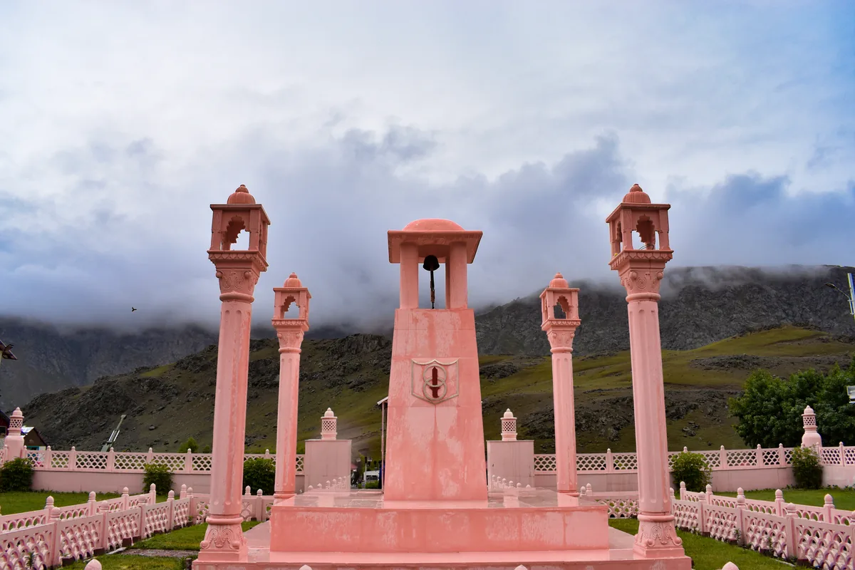
Riding east along National Highway 1 across the high-altitude windswept valley of Drass, the road straightens out beneath an amphitheater of jagged, foreboding mountain peaks. Situated at an elevation of 10,800 ft (3,292 m), exactly 5 km west of Drass town, stands the Drass War Memorial (officially designated as the Kargil War Memorial). Built and maintained with immaculate precision by the Indian Army, this solemn national sanctuary commemorates the supreme sacrifice of the 559 soldiers who laid down their lives during the 1999 Kargil conflict (Operation Vijay).
The architectural epicenter of the memorial is the pink Chunar sandstone cenotaph and the eternal flame (Amar Jawan Jyoti), burning continuously beneath the bronze-inscribed crest of the Indian Armed Forces. Flanking the cenotaph is the majestic Wall of Heroes, which carves in pristine brass letters the name, rank, and regiment of every fallen officer and jawan who gave their today for our tomorrow.
What makes standing on the memorial grounds a deeply emotional and arresting experience is the immediate geographic context. Looking directly behind the sandstone cenotaph, your eyes trace the steep, jagged vertical ridgeline of Tololing Peak rising 15,147 ft into the sky. It was here, on these near-vertical scree walls and sub-zero rock parapets, that the men of 2 Rajputana Rifles and 18 Grenadiers executed one of the most daring uphill high-altitude counter-attacks in military history, storming fortified Pakistani bunkers under heavy direct artillery bombardment.
Further to the northwest, clearly visible through high-magnification binoculars mounted along the memorial's viewing platform, rises the pyramidal snowy summit of Tiger Hill (Point 5065) and Point 4875 (Batra Top, named after Param Vir Chakra awardee Captain Vikram Batra). Standing on this soil, every motorcyclist feels the profound historical weight of the ground beneath their riding boots.
The Manoj Pandey War Gallery: Captured Pakistani Arsenals, Diaries & Battlefield Maps
Answer-First Summary: Inside the memorial museum: personal diaries, battle orders, captured weaponry, and the Param Vir Chakra citations.
Directly adjacent to the central parade ground lies the Captain Manoj Kumar Pandey War Gallery, named in honor of the 24-year-old officer of the 1/11 Gorkha Rifles who was posthumously awarded India's highest wartime gallantry medal, the Param Vir Chakra, for his superhuman valor in clearing Pakistani bunkers on the Khalubar ridgeline.
Stepping inside the climate-controlled gallery reveals a rare, deeply intimate archive of military history. Glass display cabinets house captured enemy equipment recovered from the frozen peaks of Drass, Batalik, and Mushkoh Valley: heavily weathered Chinese-made Type 56 assault rifles, G3 battle rifles, heavy machine gun barrels, anti-aircraft cannons, and mortar baseplates.
Equally powerful are the personal wartime artifacts: hand-drawn tactical battlefield maps used by Indian artillery commanders to target enemy observation posts along the highway, intercepted military transmission logs, and the blood-stained field diaries of young lieutenants and captains. Several exhibits showcase letters written by soldiers to their families in the days before final summit assaults, reflecting extraordinary patriotism, calmness, and resolve.
Inside the adjoining army auditorium, visitors are invited to view a comprehensive 15-minute documentary film screened by the Indian Army. The film provides archival footage of the 1999 war, explaining how Bofors 155mm howitzers and Mirage 2000 laser-guided airstrikes altered the strategic balance, offering vital context before you continue your motorcycle journey along NH1.
The Battle of Tololing & Tiger Hill: The Tactical Mountain Warfare Turning Points
Answer-First Summary: High-altitude mountain warfare doctrine: how Indian infantry reclaimed fortified summits at 16,000 feet.
To appreciate the monumental importance of the Drass battlefield, one must examine the strategic doctrine of the 1999 war. When Pakistani regular troops and northern light infantry infiltrated across the Line of Control during the winter freeze, they established fortified sangars (stone bunkers) atop the heights of Tololing, Tiger Hill, and Point 4875.
From these vantage points, enemy forward observation officers enjoyed unobstructed visual line-of-sight over National Highway 1. By directing pinpoint artillery and mortar fire onto passing Indian military convoys, they threatened to sever Ladakh's primary logistical lifeline to Kashmir and the rest of India. Had NH1 been cut, the entire Siachen Glacier garrison and Ladakh defense posture would have been critically compromised.
THE TURNING POINT AT TOLOLING: The capture of Tololing by the 2nd Battalion of the Rajputana Rifles on June 13, 1999, was the pivotal psychological and military turning point of Operation Vijay. In pitch-black darkness, sub-zero winds, and near-vertical rock chimneys, Indian soldiers climbed hand-over-hand without safety ropes, launching ferocious frontal bayonet charges against machine gun nests. Over 10,000 rounds of 155mm high-explosive artillery shells were fired in direct-support mode, pulverizing enemy positions before the final summit storm.
THE STORMING OF TIGER HILL: Following Tololing, the 18 Grenadiers, supported by 2 Naga and 8 Sikh, executed a daring multi-directional night assault on the glaciated 16,500-foot summit of Tiger Hill. Grenadier Yogender Singh Yadav, despite sustaining 14 bullet wounds, crawled through an enemy trench, lobbed grenades into an active machine gun bunker, and neutralized four enemy soldiers in close-quarters combat, earning the Param Vir Chakra at the age of nineteen. Looking up at those frozen cliffs today evokes awe at what human courage accomplished on these ridges.
The Mushkoh Valley Exploration: Wildflower Meadows, Nomadic Gujjars & Batalik Corridors
Answer-First Summary: Taking the scenic off-road detour south of Drass into pristine alpine meadows, shepherd camps, and Kaobal Gali.
While National Highway 1 passes directly through Drass town, motorcycle adventurers with an appetite for off-road exploration can venture into the breathtaking, untamed expanse of the Mushkoh Valley. Branching southwest from Drass, a scenic unpaved gravel trail follows the pristine Mushkoh River into an isolated alpine wilderness that remains completely untouched by mainstream commercial tourism.
During July and August, the floor of the Mushkoh Valley transforms into a brilliant carpet of high-altitude wildflowers. Vast meadows of yellow buttercups, purple edelweiss, blue Himalayan poppies, and wild forget-me-nots flourish against the backdrop of towering glaciated peaks. The valley is home to seasonal Gujjar and Bakarwal nomadic shepherds who graze massive herds of sheep and horses, living in traditional flat-roofed stone kothas.
TRAIL TELEMETRY TO KAOBAL GALI: The dirt track winds deeper into the valley toward Kaobal Gali (elevation 13,650 ft) - the remote mountain pass connecting the Drass sector with the Gurez Valley in northern Kashmir. PILOT NOTICE: While the initial 15 km of the Mushkoh trail is manageable on standard dual-sport motorcycles, pushing toward the pass summit involves loose talus scree, unbridged river fords, and sharp embedded slate rock. Riding this sector requires dual-purpose knobby tires (like the Ceat Gripp XL or Pirelli Scorpion Rally) and high technical throttle control.
SECURITY VERIFICATION IN MUSHKOH: Because the Mushkoh Valley extends toward the Line of Control, travelers must register their motorcycles at the Indian Army security outpost at the valley entrance. Hand over your vehicle registration and photo ID to the jawans. The valley is peaceful, welcoming, and offers an unforgettable glimpse of Ladakh's wild frontier ecology.
Military Protocol, Strict Dress Codes & Memorial Grounds Security Etiquette
Answer-First Summary: Understanding Army regulations: prohibited attire, helmet storage, registration, and ceremonial etiquette.
The Drass Kargil War Memorial is an active military installation and a solemn national cemetery, not a casual roadside tourist dhaba. The Indian Army strictly enforces respectful codes of conduct that every motorcycle rider must abide by.
TIMINGS & ENTRY: The memorial is open to visitors daily from 10:00 AM to 12:00 PM (morning session) and 02:00 PM to 05:00 PM (afternoon session). It is strictly closed on Sundays and during special military ceremonial rehearsals. Entry to the entire complex is completely free of charge.
DRESS CODE ENFORCEMENT: The Indian Army enforces a mandatory dignified dress code. Visitors wearing shorts, three-quarter pants, skirts, sleeveless t-shirts, or track pants with offensive graphics will be denied entry at the security gate by the military police (CMP). Full-length riding trousers, jeans, and proper covered footwear are mandatory.
HELMETS & LUGGAGE: Riding helmets, large backpacks, tank bags, and metal selfie sticks cannot be taken inside the memorial grounds. A secure baggage and helmet depository is provided at the main entrance gate where you can safely check your gear. Riding jackets and armored boots are entirely acceptable.
SECURITY VERIFICATION: Every visitor must present an original government photo identification card (Aadhaar card, Passport, Voter ID, or Driver's License) at the sentry desk and enter their name, vehicle registration number, and contact details in the visitor logbook.
The Second Coldest Inhabited Place on Earth: Weather Hazards & Riding Gear Protocol
Answer-First Summary: Surviving Drass's extreme continental climate where winter temperatures plunge to -60°C and summer nights hover near freezing.
Beyond its military renown, Drass holds a famous meteorological title: after Oymyakon in Siberia, it is widely recognized as the second coldest permanently inhabited settlement on planet Earth. During the brutal Himalayan winter from December through March, temperatures in Drass routinely drop below -40°C, with the all-time official record plunging to an astonishing -60°C (-76°F) in January 1995.
SUMMER RIDING REALITY: Even in the prime riding months of June, July, and August, the climate of Drass is defined by intense diurnal temperature variation. Midday sunshine can push valley temperatures to a pleasant 20°C, but the moment the sun dips behind the Tololing ridgeline, ambient temperatures drop precipitously toward 2°C to 5°C, frequently dipping below freezing during unseasonal rains.
RIDING GEAR RECOMMENDATIONS: When setting out on the Srinagar-to-Kargil leg, never ride in perforated mesh summer jackets without thermal liners. Always wear a 3-layer system: a moisture-wicking merino wool or thermal base layer, an insulating fleece mid-layer, and a heavy-duty Cordura outer shell with a 100% windproof and waterproof membrane. Cold crosswinds howling down from the Drass snowfields can induce severe core hypothermia within 45 minutes if your chest and neck are exposed.
CHAIN & MECHANICAL CHECKS: The gritty glacial mud on the Zoji La pass ascent acts like grinding paste on your motorcycle chain and sprockets. When halting at Drass town, inspect your drive chain: use a can of chain cleaner to strip off abrasive mud, wipe it dry, and apply a heavy coat of synthetic high-adhesion chain lube before tackling the remaining 55 km of fast highway tarmac to Kargil.
Strategic Staging: Integrating Drass into the Classic Srinagar-to-Leh Motorcycle Expedition
Answer-First Summary: How to schedule fuel stops, meal halts, and overnight staging between Srinagar, Kargil, and Leh.
Careful route timing is critical when traversing the Srinagar-Leh highway. Most experienced motorcycle expedition leaders structure their itinerary using one of the following tactical plans:
STANDARD 2-DAY TRANSIT: Departing Srinagar or Sonamarg at 06:30 AM allows you to cross Zoji La before civilian truck convoys create bottleneck jams. Arriving at the Drass War Memorial by 11:30 AM provides 1.5 to 2 hours to tour the grounds, watch the documentary, and reflect at the Wall of Heroes. You then ride 5 km into Drass town for a warm lunch of mutton rogan josh or vegetable pulao at a local roadside dhaba, topping up your fuel tank at the Drass IOCL petrol pump before cruising 55 km into Kargil for an overnight hotel stay.
THE OVERNIGHT HALT IN DRASS: For riders who prefer avoiding the commercial bustle of Kargil, Drass town features several clean, basic hotels and Jammu & Kashmir Tourism Development Corporation (JKTDC) tourist bungalows. Staying overnight in Drass provides an opportunity to explore the lesser-known Mushkoh Valley - celebrated for its wild alpine meadows and dramatic battlefield ridges - before proceeding east toward Mulbekh and Leh the following morning.
The Bofors 155mm Howitzer & Artillery Precision in Direct-Fire Mode
Answer-First Summary: How Indian field gunners deployed 155mm howitzers in direct-fire role, blasting enemy bunkers on Tololing and Tiger Hill.
Mounted on ceremonial concrete plinths on the memorial perimeter are the legendary weapons that reshaped modern mountain artillery warfare: the Bofors 155mm Haubits 77B field howitzers and 105mm Indian Field Guns (IFGs).
During the 1999 conflict, the Indian Army Artillery faced an unprecedented tactical challenge: enemy bunkers were carved into the reverse slopes and sheer cliff faces of Tololing and Tiger Hill at 15,000+ feet, rendering conventional high-angle ballistic artillery trajectories largely ineffective against reinforced stone sangars.
In an audacious operational innovation, Indian artillery regiments manhandled multi-ton Bofors guns right up to the edges of National Highway 1 and elevated terraces in the Drass valley, engaging in 'direct firing' mode. Gunners aimed their heavy howitzer barrels horizontally directly at visible bunker embrasures through optical sights, firing 43 kg high-explosive shells with pinpoint laser-like precision.
Over 250,000 artillery shells were fired across the Drass and Kargil sectors during Operation Vijay. The thunderous roar of dozens of Bofors guns firing simultaneously earned the artillery the title of 'The Ultimate Game Changer.' Standing beside these historic guns today allows riders to appreciate the extraordinary ingenuity and firepower that preserved the national highway.
Route Milestones, Elevation & Road Conditions
| Milestone | Elevation (ft / m) | Distance from Srinagar | Road Condition & Key Facilities |
|---|---|---|---|
| Srinagar Dal Lake | 5,200 ft / 1,585 m | 0 km | State capital, major airport, houseboats, full repair shops. |
| Sonamarg Valley | 8,960 ft / 2,731 m | 80 km | Major tourist hub, hotels, fuel station, Zoji La staging point. |
| Baltal Base Camp | 9,200 ft / 2,804 m | 94 km | Amarnath Yatra staging ground, start of unpaved Zoji La climb. |
| Zoji La Pass Summit | 11,575 ft / 3,528 m | 108 km | Challenging mud/gravel pass, UT Ladakh border, heavy truck traffic. |
| Gumri Military Post | 11,200 ft / 3,414 m | 115 km | Start of smooth BRO blacktop, memorial viewing, military post. |
| Drass War Memorial | 10,800 ft / 3,292 m | 155 km | Operation Vijay memorial, Manoj Pandey museum, Tololing views. |
| Drass Town Market | 10,760 ft / 3,280 m | 160 km | 2nd coldest inhabited town, IOCL petrol pump, hotels, dhabas. |
| Kargil City Center | 8,780 ft / 2,676 m | 215 km | Major transit city, Suru River, hotels, ATMs, mechanics, fuel. |
| Mulbekh Chamba Rock | 10,800 ft / 3,292 m | 255 km | 30-ft ancient Maitreya Buddha, twin monasteries, tea stalls. |
| Fotu La Pass Summit | 13,479 ft / 4,108 m | 300 km | Highest pass on NH1, pristine BRO blacktop, TV tower. |
| Leh Main Market | 11,562 ft / 3,524 m | 425 km | Capital of Ladakh, Ride & Fire Rentals, hospitals, airport. |
Ready for Your Ladakh Motorcycle Adventure?
Navigating the complex checkpoints and steep elevations of UT Ladakh requires both legal compliance and mechanical reliability. At Ride & Fire Rentals, we offer locally registered motorcycles with the mandatory LA-02 yellow commercial plates, ensuring you clear every military and union checkpoint seamlessly. Our fleet is 100% fuel-injected and thoroughly checked before every handover at our Changspa Road workshop.
For external travel planning references, you can check the official Ladakh Tourism Portal or apply for permits via the LAHDC Leh Permit Portal.
Season Launch Offer
Book your motorcycle direct from our Changspa Road facility. Get a standard 25% direct booking discount, plus enter coupon code LADAKH5 at checkout for an extra 5% off (saving nearly 30% total) on your entire rental! This promotion is active until June 30.
Frequently Asked Questions
What are the official visiting timings for the Drass War Memorial in 2026? +
The Drass Kargil War Memorial is open daily from 10:00 AM to 12:00 PM (morning session) and from 02:00 PM to 05:00 PM (afternoon session). The memorial is closed on Sundays and during official Indian Army ceremonial parades. Entry is completely free.
What is the dress code for visiting the Drass War Memorial? +
The Indian Army enforces a strict respectful dress code. Visitors must have shoulders and knees covered (full-length trousers and shirts). Shorts, three-quarter pants, skirts, and sleeveless shirts are strictly forbidden. Motorcycle riding trousers and jackets are fully acceptable, but helmets must be deposited at the security gate.
Is photography and videography allowed inside the Drass War Memorial? +
Yes. Photography and videography are permitted on the exterior grounds, including the Wall of Heroes, cenotaph, Amar Jawan Jyoti, and military artillery displays. However, photography inside the Manoj Pandey War Gallery museum is strictly prohibited. Commercial aerial drones are strictly banned.
Can I carry my motorcycle helmet and riding luggage inside? +
No. Helmets, large backpacks, tank bags, and metal luggage cannot be carried into the memorial grounds for security reasons. The Indian Army provides a safe, free helmet and baggage cloakroom at the entrance security gate.
Where is the nearest petrol pump to the Drass War Memorial? +
The nearest fuel pump is an authorized Indian Oil Corporation (IOCL) petrol station located in Drass town, exactly 5 km east of the memorial. Heading west toward Kashmir, the nearest fuel station is at Sonamarg (75 km away over Zoji La).
How far is the Drass War Memorial from Kargil and Leh? +
The Drass War Memorial is located 55 km west of Kargil (approximately 1 hour of smooth riding along NH1) and 270 km west of Leh (approximately 6.5 to 7.5 hours of riding via Fotu La, Namika La, and Khaltse).
Do you need an Inner Line Permit (ILP) to visit Drass? +
No. Drass lies directly on National Highway 1 (Srinagar-Leh Highway), which is an open national highway corridor. Neither domestic Indian citizens nor foreign tourists require an Inner Line Permit to visit Drass or the War Memorial.